Friday, December 30, 2011

Nowhere Special

Soon after my good buddy Mike Lowrie took me on my first MTB ride (in early 1998, down Red Rocks), he and his partner Linn gave me my first copy of "Classic New Zealand Mountain Bike Rides, 3rd edition".  My next was the 5th, and I now have the full set, thanks to the Bros themselves and a bit of trademe action.  I enjoy flicking through each new release, searching for motivation, and there's always plenty.   

A special ride first appeared in the 7th edition:  Bridge to Nowhere, in the Whanganui National Park.  By now, I was fast friends with Simon, and had heard on a couple of occasions his account of the Bros' "ride" through this loop in the late 80s.  The scale of the write-up when it finally appeared (prior to the 7th, it had been an out-and-back ride to Mangapurua Trig) hinted that this particular trip was something else, and it's since been on my to-do list.  A subsequent canoe trip down the Whanganui a few years ago did nothing but make me want to ride there even more.  While I'd now seen the Bridge, I wanted to be on a bike when it appeared out of Nowhere.

Finally, the pieces fell into place. Jo and Dave did a great job of booking a jet boat while I was away touring with Marjolein.  We'd be joined by Matt and Sarah, and the five us were booked for a 4pm collect on the 27th - a perfect way to use up recently stored Christmas calories. 

We rendezvoused early in the morning at Sarah's family crib in Rangataua, not far from Ohakune.  With five of us riding, we'd enlisted Simon and Miro to help with the logistics, and after a short drive, four bikes were being unloaded from the two cars at Ruatiti Domain.  I was soon back at Raetihi, parking up next to Dave's car at the holiday park, and as 10:30 clicked over on my clock, I was rolling out.

My day's ride started fast - I had an extra 22km to ride back to Ruatiti Domain and including my drive back to Raetihi, I'd given the others an hour's head start at the domain!  About 3km along the highway towards National Park was the well sign-posted turn off, and the first grand sign featuring a logo which with luck will soon be commonplace around the country.


After a few undulating kilometres. the road tipped downwards, and I was afforded great views down towards the river. 


Despite being keen to catch my cobbers, I couldn't resist stopping to investigate a sign we'd seen on the drive in.


Alas, it wasn't much more impressive up close, but better to regret something you did than something you didn't.

The descent was over pretty quickly, and a few kilometres away from the domain, I met Simon and Miro heading back to Rangataua.  We wished each other a good day, and I headed off, soon to be accosted by a stunning view up the Manganui o te Ao River.


That bridge marked the end of the tarseal, and a few minutes later I was past Ruatiti Domain and into foreign territory.  As with my cobbers up the road, I entertained myself trying to work out when I'd catch them. Simon had predicted I'd see them before the top of the main climb, and while I had no idea how likely that was, I kept banging away at the pedals...  And, stopping for photos.  The highland cattle at Ruatiti even seemed worth a short backtrack after I'd blasted past them.


When I reached the start of the Mangapurua Track I had a short breather, before steeling myself for the climb (by taking some more photos). 

No worries!
The Kennett Bros' ride profile made the climb appear steep, and so I was pleasantly surprised at the relatively mellow gradient.  There were a few gates to negotiate, but otherwise the track was in great condition and the riding was fast.  A sign indicated I'd just entered the Takahe Conservation Area, and this marked the end of the main climb and the beginning of an undulating section along the ridge to the trig.

After a few more minutes enjoying my impersonation of an XC racer, I spied ahead a bunch of four - the breakaway had been reeled in!  I quickly learned Matt had won the "when will we see John" sweepstake, and the peanut slab prize.  It was just after 12:30, and about time for a bite to eat.  We stopped at a gate and letterbox - number 2 - only a hundred metres short of the top end the Kaiwhakauka Track from Whakahoro.

It was especially nice to see my bro Dave enjoying himself.  If memory serves me correctly, the sum total of his MTB experience is:  Queen Charlotte Track and a couple of hours in Rotovegas back in the late 90s, a ride through Long Gully and along the South Coast with Kaitlyn and I four or five years ago, and Tree Trunk Gorge this time last year!   As we blasted along together, it was very cool to see him on board my Flux, and it made the ride that much more special for me to see him enjoying something I love doing. 

Dave, on his first MTB ride of 2011!

The views along this section were so good we made a couple of stops.  During one, I almost came a cropper falling down a bank after setting my camera's 10-second timer! 


After promising Matt a few times that the Trig was imminent, it finally appeared to his and my relief, along with a toilet (to Jo's relief)!  Miles away from Nowhere still, but well catered for.


We'd been regularly passing signs marking the names of the settlers who'd lived in this area.  I caught myself joking that they were pikers, before more carefully thinking through the circumstances that brought them to this wild place, and realising what a hospital pass they'd been thrown, and how hard it must have been to turn their back on it.  I felt ashamed for my initial comments. Those poor, hard bastards...


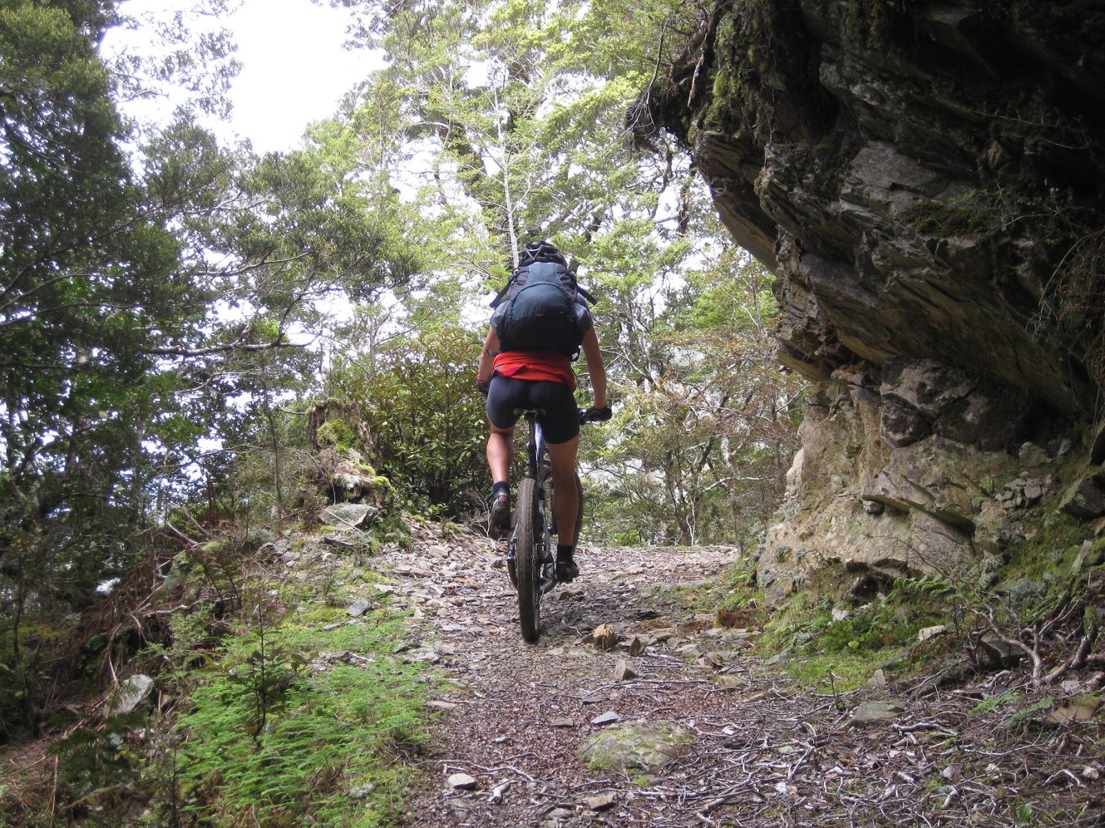
We didn't bother climbing the short track up to where we presumed the Trig was, and instead cracked into a rip-snorter of a descent down into the Mangapurua Stream valley.  I followed Dave all the way down, and was impressed with how well he was handling the Flux.  I was also glad that the track was in such good nick, and didn't often offer up curly surprises!

Down in the valley, we came across the first of many swing bridges.  We all walked the first one but subsequently discovered that the bridges were mostly rideable - just the beginning and end took a bit of negotiating with our wide handlebars.


The riding along the valley was pretty cruisy.  Sections through bush were interrupted by grassy clearings, and the biggest challenge was avoiding the thistles lurking in the long grass at the edge of the track.  The track surface was almost always dry and predictable, and we were making good progress.  Nonetheless, time was marching on, and we made regular stops for photos and food!


As we neared the Whanganui, bluffs became more common and here the double track would become a very narrow bit of singletrack perched half way up a sometimes sheer face.  Signs warned us to dismount, and to not all be on the bluff at once, lest many birds be killed by one stone.

It was always a relief to ride past the sign reading "Safe to remount"!


Battleship Bluff was the most impressive of these sections.  It was bizarre knowing the scale of the Bridge up ahead, and trying to imagine what would have prompted them to build such a major structure with these frequent pinch points on the access to it.

Matt safely negotiates Battleship Bluff, recorded by Dave and I!
The view from Battleship Bluff down to the stream was absolutely stunning, and a sharp reminder of the power of erosion and the costs of a stuff up at this point!


DOC had done an impressive job with signage along the track, and every so often, at least one of us would heed the advice to the letter.


It was after 3pm when we finally burst out of the bush onto the Bridge and through a dozen or so people being told by their jet-boat operator of its  history and that of the unfortunate settlers. 

We didn't have too much time up our sleeves, but nonetheless we enjoyed the views down to the stream from our vantage point high above it, and a bit of a spell off the bikes! 


I blasted ahead on the track to the river which I'd walked a few years earlier, longing for my bike.  I was feeling a hell of a lot more nimble than earlier in the day when I'd had a backpack stuffed with water, tools, brownie, PB&J sandwiches and one square meals, and it was fun to let rip for a bit!

When I reached the landing, already there was another party of three cyclists - parents and their 12-year-old daughter - and some trampers.  Eventually Dave, then Matt, Sarah and Jo arrived, and we sat for a while admiring the massive Whanganui River slipping silently by.

Looking upstream
 
Our jet boat operator arrived a few minutes after we'd begun to get a little nervous, but within acceptable limits of the 4pm booking.  Soon there were 8 bikes stacked on the racks at the back, and we were getting our in-flight safety briefing.


My inner bogan was awakened immediately upon the engine being fired up, complete with its lovely throaty growl.  Within seconds of my first ever jet-boat ride beginning, I was in seventh heaven, and a big grin was spread across my face as we blasted away from the landing!


My GPS unit out of reach on the stem of my bike, I could only guess at our speed.  In any case, the 30-odd kilometres we travelled down river passed without any energy expense, and was a quirky highlight of this mountain bike ride!  En route to Pipiriki, we passed a few canoes and kayaks, and made one stop across from Tieke Kainga, where a few years earlier I'd awoken on Easter Sunday to find the locals had slipped eggs under everyone's tents.

Despite my bike being the last on and first off, I helped unload the boat at Pipiriki.  That done, I didn't linger while the bikes were loaded onto the shuttle van, and slipped away before the temptation of the easy option overcame me.

As with the start of the day, I was back in race mode - this time away from my cobbers.  I'd done this climb twice already - back in 2008 with Simon as an out-and-back, and earlier this year at the end of day one of the Tāwhio.   On the one hand I was disappointed to find the whole thing had been since sealed, but on the other, I was pleased for the slightly easier ride.  The catch was inevitable, and it came just before the top of the main climb.  Luckily I was offered only encouragement (and not a seat in the van), and I kept plugging on towards Raetihi.

I'd said goodbye to Dave and Matt down in Pipiriki.  As I rode through Raetihi, I expected they'd be out of their riding gear, and heading towards Taupo with golf on their minds. 

My legs started to wane as I started the road to Ohakune, and I struggled to muster 30km/h.  It didn't help that the road was gently climbing, but the largest factor was the fatigue in my legs.  About 10 minutes out of Raetihi, Jo and Sarah drove past in my car, four bikes on the back, and plainly surprised to see me.  They slowed, giving me the opportunity to wave them down.  Instead, I reluctantly waved them off...

Despite being only 5km from home, I stopped at the servo in Ohakune for a chocolate milk and a red bull.  I didn't spare much thought for which was the least gross order to drink them in, and instead skulled one after the other.  The ride to Rangataua, still uphill, passed slowly but surely, and I was soon at home and getting cleaned up for an evening of food and stories.

Simon and Miro had had a great day, as had the five of us on our special ride to Nowhere.  Our group had a huge range of cycling backgrounds: from Sarah's two decades of cycle touring and MTBing to Dave's once every year or two, with Matt, Jo and at various points in the spectrum between.  Nonetheless, we had all had a ball.

For my part, the ride was everything I'd hoped it would be.  I really enjoyed Jo, Sarah and Matt's company, but particularly revelled in riding with my bro.  Between Tree Trunk Gorge and this year's ride, we've established a fine tradition.  I wonder where we'll ride together at the end of 2012?!  Perhaps we'll even get out before then.  I can't wait.

Monday, December 26, 2011

Gearing up for Christmas

A welcome distraction from the stresses of work, and what seem to be common post-event blues, was an email from Marjolein Ros, Ashley's business partner at Revolve Cycling.  Marj was not only asking about MTB touring opportunities in the top of the South Island, but also inviting me to join her.  After initially writing it off as impossible, I soon realised I could totally afford the time, and after committing, had only a few days to be excited about the impending trip!  Game on!

We'd agreed to check out 3 out of 4 days of the trip I'd had planned for easter, but had ditched to play dress ups!  Namely, the Waikakaho Track from Linkwater on Queen Charlotte Drive to Renwick in the Wairau Valley, the Wakamarina, and the Maungatapu Track over to Nelson.  Linking these rides up would be only short sealed sections, and in total, we'd have an awesome bit of mountain biking on our hands.

Things became a little tenuous in the final days on account of massive slips and flooding in Nelson, so much so that by the time we sailed for Picton, we still weren't sure about our final day.  We knew enough to ditch any thought of a pass over Dun Mountain, but weren't entirely certain we'd be able to get through the Maungatapu.

Marj was pre-booked on a full Bluebridge sailing, so while we didn't get to chat on our Cook Strait crossings, I could occasionally watch her out the window.

Marjolein rounding Point Halswell

Both ferries were delayed slightly, so we didn't hook up in Picton until after midday, at which point we made straight for the Dutch bakery!  I was hoping Marjo would bust out some Dutch, but had to make do with some recommendations of which traditional cakes to buy!!!   We had a bit to eat in the garden there, before saddling up, and hitting the road.


We'd never done a trip together (let alone a ride), so it was great to get stuck into getting to know each other better.  The traffic was pretty light, so we could ride two abreast for the most part, and the road bash to the Linkwater store was over before we knew it!  We mixed up some sports drink, and bought an apple each, which we ate out in the sun.


A Flux and a Stumpy.  Perfect touring bikes, for this trip!
The store is just opposite Cullensville Road, which is the access to the "Linkwater Long Cut", aka the Waikakaho Track, and we were soon blasting along its metalled surface.  As we rounded a bend, we were confronted by a herd of cows, lead by a stroppy looking bull.  With trepidation we made our way through them without incident!

Safe!
The gravel road ended at a gate, and we were soon over it, and the stream just beyond it.  I'd been through here with Simon a few years earlier and so, despite a lack of signage, knew the suspicious gate on our right was the one to take.

We left the valley floor on a wide bench covered with recently cut grass.  As we climbed, we both realised what a mission it would have been before the grass had been cut - the trimmings were over a foot long, and there was lots of it - and we were musing about how recently the mowers had been through.  We'd settled on a few days, when we were confronted by our saviours!  We'd been out by a few days, give or take an hour or two!  

Thanks team!!!!
As in 2009, I really enjoyed the climb, and I fared a bit better on the upper slopes.  I was managing the left switchbacks much better than the right ones, but wasn't having to walk too much, which was nice.  Marjo was faring similarly well, but we laughed at the mind boggling effort Simon had posted last time to ride the whole thing.

Looking down to Linkwater

The last few hundred metres of track to the ridge were in beech forest, and were unridable, so our legs got a bit of respite from the granny-gear climb, and a hammering of a new sort.  Eventually though we were at the top, and after a short stop, we began picking our way across the ridge on foot. 


Eventually, the ridable sections began to get longer and longer, and finally, we were able to spend reasonable periods on the bikes between dismounts.  When the track finally began to drop on the Wairau side of the range, we were presented by a greasy rocky bit of singletrack!  It came as a bit of a shock to my system, and I was riding very tentatively.  My nerves may well have been less of an issue with slightly less pressure in my tyres and a few more recent MTB rides under my belt, and I was beginning to worry about how much walking we'd be doing!

As we descended, the track became drier, and things settled down a bit.  Then, the next curveball arrived when we found ourselves at a mine shaft, and the end of the track.  In hindsight, things were pretty obvious, but at the time, we thought the track continued beyond the mine.  Neither of us had seen a turn off, and there was plenty of windfall around which could have been obscuring the route.  We poked around for at least 10 minutes before eventually concluding we needed to turn back.

As we retraced our steps, we were both contemplating the unpleasant thought of retracing our steps.  "Tyre prints" would have been appropriate, but for the majority of the last hour being on foot.  After about 200m though, we were flooded with relief on meeting a switchback turn - which the out-and-back track to the mine met at its apex.  We'd both been so intent on a small drop over a root in the corner, we'd overlooked the main track turning to our right.  Phew!  Or, more accurately, PHEW!!!!

The riding beyond this point was an absolute blast, no doubt enhanced by the sensations of relief!  We made a short stop at the relics of a small settlement, which consisted of one stone chimney, and a stone throne! 


Queen Marjolein
I'd discovered a weakness of my touring setup on the upper part of the descent, namely, I'd blown my Ortlieb seat bag off its mount a couple of times when riding down a couple of drop-offs.  Luckily, I had space in my Camelbak Octane 18X bag, and without the seat bag, I was feeling much more comfortable on the technical sections.

There was a particular section of track I was very much looking forward to - an impressive rock bluff with cliff below it.  Simon had tried to get a decent shot of me riding around it, but hadn't been pleased with his photo.  When I arrived, I quickly leade the bike down and scrambled up the bank while retrieving my camera.  No sooner had I turned it on, then it was time to snap Marjo making her way around it. 


We didn't bother setting up for another, and continued our blast down to the valley floor!  Whoop whoop!

We were soon at the end of the track, and after an occasionally boggy 4WD road, we turned right onto the Kaituna-Tuamarina Road.  We had about 45 minutes to get to Renwick before the store closed, and eventually we decided I should make a dash for it.  After discussing a grocery list, I was off, and enjoyed a solid TT effort into Renwick.

Supplies in hand, I was just unlocking my bike as Marjo rode in, and we walked together to Watsons Way Backpackers before washing up and getting dinner ready.  We ate at a large dinner table, and had a European couple nattering away to each other while MJ and I swapped adventures from earlier in the year.

The following morning, I was stunned to learn the other couple had been Dutch, and they'd been translating Marjolein and my conversation!  Little did they know, Marjolein had understood every word they'd said!  RUDE!!!  I wish I'd known, I would have begged Marj to bid them goodnight in Dutch.

My good friends Dave and Tim had ridden the Wakamarina a couple of months earlier, so I knew we needed to detour along to Bartlett's Creek rather than take the more direct Onamalutu Road climb up to the start of the track.  The longer route was nice, and the traffic on the road dropped away significantly after the Onamalutu turnoff. We had great conditions again, and with the short sealed section out of the away, it was time to get ready for a 1000m climb!


The first 600m of it was on a gravel road, and was initially very gentle.  We had a few fords to ride through, and the water passing over them was so crisp and clear.  I finally made the decision to stop at the next one for a photo, when as luck would have it, the road kicked up, and we left the stream crossings behind!

The climb was sizable, but rarely steep, and it ticked away quickly enough.  We stopped occasionally, and had fun trying to work out where we'd be riding.  The Wakamarina track would take us across the Richmond Ranges, and the first of two high points would be Fosters Clearing, in a saddle obscured by my head in the next photo!


After admiring the view down into the Wairau Valley, in which we could just make out the Waihopai spy base, we were soon off-road, and into some glorious beech forest track. 


The track was overall less steep than the gravel climb up to it had been, but it wasn't entirely straightforward riding.  The surface was dry, and mostly smooth, but it was often covered with so much leaf litter that progress was hard earned.  In any case, it was pretty sweet riding, and would have made for an awesome out-and-back trip.

Are we there yet?!


Climate control was tricky - as we climbed, the temperature was dropping slightly, and while I was sweating, I still was feeling kind of chilly.  My sleeveless jacket went on and off and on and off, but eventually, we burst out of the bush into Foster's Clearing and beautiful blue skies.


From the clearing, we had a 200m vertical descent, after which the Kennett Bros said we'd be on foot.  They were true to ther word, though I'm sure they should have had "grovel" somewhere in there.  The 200m were hard won, and when the miserably hot push was finally at an end, Marjo and I sat for a rest in what I'm sure would make a perfectly good helipad!

The main descent was to be 800 vertical metres in about 2.5km, and conditions could not have been better for us two nanas to hit it up. The track was bone dry, remarkable given the rain Nelson had experienced not a week before.

"Switchback City Arizona" was a pretty good description of the track, and Marjo and I made a conservative but effective fist of it.  We had no crashes, and a hell of a lot of fun with only a little bit of walking.  There were a couple of drops I might have tried with my seat down and an ambulance on hand, but there were also a few that were well beyond my capabilities!

Before too long we were down in the valley, and the crossing of Doom Creek demonstrated the waters were just as clear on the north side of the range as on the south side.  The prospect of a solid meal was about the only thing that stopped us going for a swim!  Well, that and knowing how damn cold the water would have been!

Doom Creek
Big-ass hills in the background!
The ride out to the Wakamarina Road-end was sweet, and much less arduous than much of the riding had been.  On the other hand, the "15 easy-kilometres" down-valley seemed less so!  A very large proportion of the properties in this valley were for sale, but the numbering system on the letterboxes gave us welcome progress of our ride into Canvastown.

Trout Hotel was waiting for us at the end of the road, on the intersection with SH6, and we were soon relaxing in the sun - the 75km ride had taken us just under eight and a half hours, and it was bloody nice to sit down!

As I made good headway into a pint of Radler (a fitting drop, I thought), Marjo experimented with my new tripod, not so successfully! 

It was worth a crack, Nigel!
Which one's next?!
After a big meal at the pub, we went in seach of cell-phone reception.  Marj had packed jandals - far too heavy - but worth their weight.  My bare feet were being reamed by the road, and I made fun of myself on behalf of Marjolein, who was very gentle on me!  Unlike the road surface!  To add insult to injury, we didn't find any reception...  Maybe I need to rethink my jandals policy?

The next morning dawned even more beautiful than the previous two days - not a cloud in the sky - and we were in for a stunner.
Ready to leave Canvastown
As with the previous two days, we commenced with a short road ride - this time, 10 kilometres or so to Pelorus Bridge.  Here we made a short stop to phone home, and prepare for the Maungatapu climb!  We met an Austrian cycle-tourist, who, between puffs on his ciggy, described his impending ride on SH1 to Christchurch.  On a carbon fully with a HUGE load?!  We suggested he investigate going through the Molesworth and left him to it!


After buying a couple of monstrous cheese scones from the cafe, we were about ready to leave when a ute swung in, driven by NZ MTB celebrity Brenda "Bob" Clapp.  She was on a work trip out of Nelson, and we had a good natter before parting ways.


I vaguely remembered the next bit of riding from the end of Day 1 of the Kiwi Brevet, and enjoyed taking it a bit more gently.  Once again, the scenery was stunning, and the waters clear.

The Pelorus River from Maungatapu Road

I was about to lose my GPS unit - on its single charge from home - but not before it suggested we'd missed the Maungatapu Track turn off.  Luckily the map data were off, not our eyes, and just as I was beginning to worry, we were presented with conclusive evidence we were OK! 

Blinkers on, and up we go!

The climb was stunning, and took us almost exactly an hour.  As if to torture us, the day became hotter, the track steeper, and the track rougher as we neared the top.  We both stayed on our bikes though, but not without physical cost!

We had plenty of time to reach Nelson to hook up with Marjolein's partner Al, so we enjoyed sitting in the sun at the top for about an hour.  The views to south were partly obscured by cloud, but to the northeast they were off the hook! 


Eventually, we started to cook in the sun, and made the decision to head down.  It was great to be on our trail bikes once again, and we enjoyed the blast down the Maungatapu.  Belying the freakish rain Nelson had had the week before, the track surface showed no sign of anything abnormal.


Near the bottom, we blasted through a rock garden I'd effectively forgotten all about.  I was glad I wasn't on my lightweight rigid bike like last time.  Urgh!

Maitai Dam
There were a couple of short but savage climbs as we made our way around Maitai Dam.  Here we saw the only signs of storm damage - a bit of windfall, and a couple of very large cracks in the road surface.  If I were a betting man, I'd put money on a bit of the road disappearing into the dam pretty soon.  Stink.

At the road end, a sign indicated we needed to take a singletrack section to bypass some works, a message consistent with Bob's advice.  But, it was ambiguous about where the track began, so I ducked up to a caretaker's home, and was told we could actually take the road if we wanted to.  When we saw the singletrack at the bottom of a fairly steep descent, we figured we'd done enough hard work, and took the cruisy option along the road.

I felt guitly as we rolled along, and occasionally glanced up at the MTB track on the hill above us, kind of wishing I was up there, but simultaneously glad I was not!  Another time, perhaps!

Maitai Valley Road spat us out into the city centre, but not before we'd seen stark evidence of the storm damage.  I grabbed a lock from a bike store, before settling down at a cafe, a change of clothes, and a delicious risotto for him, and a kebab for her.

Shortly after, I was wishing Marjolein farewell and a Merry Christmas, and soon after that, I was off to the airport.

The short flight back to Wellington was great apart from the fact I was looking out the left side of the plane.  I knew those on the right were getting unrestricted views of three great MTB rides:  the old-school Maungatapu Track, and the sublime Wakamarina and Waikakaho Tracks, complete with plenty of hike-a-bike and technical sections.  Marjolein's company had been awesome, and our pace had been cruisy but deliberate.  It was truly uplifting stuff, and the perfect way to bring the working year to a close.