Our trip to Tasmania didn't get off to an auspicious start, falling victim to the short-lived Australia-NZ bubble in the second half of 2021. On the upside, by the time the October trip was cancelled, I'd got far enough through the planning to realise that a single week wasn't nearly enough. When we rebooked for Christmas 2022 (literally, saving a cool $1500 by leaving home on Christmas Day), I doubled the length of time on the island.
Travel-prep was relatively straightforward. I dusted off the boxes we'd used at the end of last summer's South Island tour and duly packed two lightly-used-in-the-interim Opens. Sarah's Di2 battery was brand new, having recently been warranteed, so we were hoping for smooth sailing on that front.
Our holiday started an evening early - after a lovely Christmas Eve dinner with our daughters and my parents, newly restricted driver Khulan dropped us down at the airport for bed-time at Rydges, all the better to ease the burden of a 6am domestic flight to Auckland.
 |
| Rydges Wellington Airport, making cyclists feel right at home with their lobby display |
The airport transfers and flights were relatively uneventful, and once through immigration at Hobart Airport, we assembled the bikes for the 20km ride into Hobart itself. It was warmer than we were used to, and we had a decent hill or two to negotiate, but it was nice to be rolling.
 |
| A nifty bridge over Rosny Hill Road |
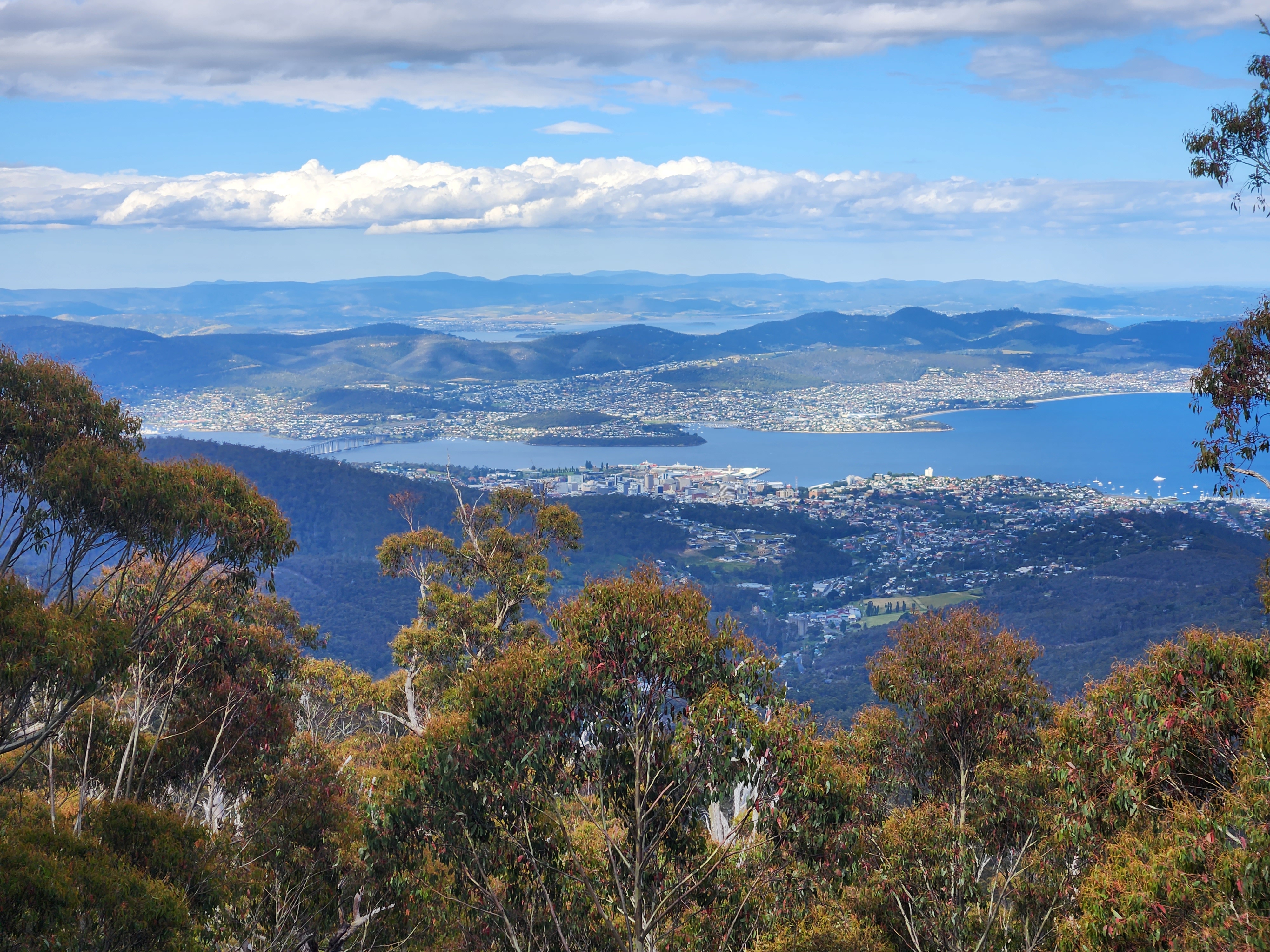
As we approached the Tasman Bridge, which would take us across the Derwent River, we could see Mt Wellington looming over the city. What better to dredge out some muscle memory...

After finding our accommodation and ditching most of our luggage, we made our way onto the Hobart Rivulet Track which made a great start to the whopping 1300m ascent. There wasn't much traffic on the road, giving us plenty of ability to focus on the incredible views.
 |
| Looking back towards the city, about 4km still to climb |
After a few minutes at the summit area, I put our map down the front of my shirt to cut out a bit of the wind chill, and we made our way back down to our digs, stopping only for photos, and a minute away from home, some supplies from a service station. When I came out of the store, Sarah was chatting with a local, who'd shown interest in our bikes and plan.
On the way to dinner, my gear shifting was unresponsive, but after removing and replacing the various plugs (with the specific Shimano tool, as instructed), including the one into the internal battery, things came back to life.
After a bit of hunting, we finally found a open restaurant - Nepalese for a nice change - and we were well fed by the time we left!
Stats: 64km ridden, 1500m ascended (most of it in a single 20km climb), max temp 36 degrees.
Day 1 - Hobart to Bothwell
We had a mighty fine start to the day, with a cooked breakfast and barista coffee from our B&B host Kevin, as well as great conversation with a Vietnamese family who were near the end of their holiday in Tasmania. We inspired them to drive up Mt Wellington once they were done with breakfast.
Things took a turn for the worse 100m into the ride when I attempted my first gear change of the morning. I followed the same strategy as had succeeded the previous evening, but to no avail. This left me with a frustrating choice: find an open bike store which also had workshop capacity to diagnose and fix the problem suitably quickly to enable us to make our first night's accommodation in Bothwell (a hell of a lot of ifs, especially on Boxing Day) or... ride on. It had been quite a challenge booking accommodation as it was, and most of the highlight were packed into the first half of the trip - aside from the financial hit, plus a scramble to find alternatives, I really didn't want to miss what I had planned.
We did a lap of the city centre and passed at least one closed bike store, from which I assessed we had a vanishingly small probability of having the issue resolved. So rather than chew up time and energy flailing around, I decided I'd rather chew up time and energy nursing a single speed bike around Tasmania. The gear I was in seemed as good as any: small chainring in the front (31-tooth), and fifth sprocket of 11 at the back (19-tooth), even though it wasn't at all clear that I could do anything about that. Onwards!
We departed Hobart on the "Intercity Cycleway" which took us a fair way out of town. It was fairly flat, which gave me a good sense of what the gear would be like on some of the worst terrain. I started getting used to spinning furiously and then coasting sufficiently long to let my speed drop to the point that I could briefly get on top of the gear again. Rinse and repeat. We were moving forwards at least.

We crossed the Derwent River on a neat old bridge that took us into Bridgewater. It would have been fun to see the middle section of the bridge being raised, but we had to make do with photos washed down with lunch from a local supermarket. I impressed Sarah by buying much less food than usual!
 |
| The Midland Highway Bridge |
After a few minutes alongside the A1, we turned off onto Ellerslie Road, designated C185. After an hour or so, by which time we were more than ready for a cold drink, Sarah mistook a family BBQ for a shop, but we were quickly set straight - no stores until Bothwell, which is where we'd be staying.
 |
| Marked Tree Rd |
Our accommodation was at Ratho Farm, a couple of kilometres out of town. After getting our room sorted, my next query was whether or not they had a pair of pedals they'd be willing to part with. I vaguely recall Thomas Lindup finishing the first Kiwi Brevet with a setup I was trying to emulate - one scrounged pedal. Soon enough a lovely young man was delivering me a pair of cheap plastic flats - he claimed they weren't using the bikes much these days on account of the horses, but my suspicion was that his delivery vehicle (an e-scooter) was the more likely substitute! Problem two sorted, I also plugged my bike into Sarah's battery to discover my bike fully responsive. Having experienced the 31-19 gear in both extremes of unfavourable terrain (flat and steep), I decided to stick with it, but it was a relief to know what the sole issue was. Launceston was only 540km and five days away - perhaps I'd be able to fix replace the battery there...!

Stats: one dead battery and one dead pedal, the latter duly replaced. 92km ridden, 1150m climbed, max temp 40 degrees
Day 2 - Bothwell to Lake St Clair
The next morning we were first at the breakfast table, and soon had bellies full. Thanking the hosts for the pedals and their hospitality, we set off on a lovely gravel sector which took us across to Ouse on the Lyell Highway (A10).

Even by the time we got there, the temperature was already well into the 30s, and climbing. We had an early lunch, topped up bottles, and then set off on the highway towards Tarraleah, which we assumed to be where our next shopping opportunity would be.
We were headed into the Central Highlands, so no surprises that more often than not, we were climbing. My gear dictated a faster pace than Sarah was comfortable with, and when some shade was on offer (which was rare), I'd often sit and wait for her. She wasn't sweating much, which worried me a little, and each time we met, she reported having trouble with the heat.

Short periods in the shade wasn't cutting through her overheating, so I was keeping my eye out for water that might be suitable for cooling off in. I rejected a couple of options due either to the colour of the water or access challenges, but did eventually identify a stopping spot.

Once underway again, I was alarmed by how slowly Sarah was moving. At one of our many stops, she asked to have a short nap, but couldn't settle due to the flies. Besides, I wanted to keep moving - we were only a few kilometres away from Tarraleah, and, as I was imaging, an air-conditioned cafe... I began getting frustrated that despite me silently pushing a single-speed with one flat pedal (that due to the shape of my shoe sole kept settling in an uncomfortable position under my foot) and hauling most of our luggage, she was the one complaining about the conditions, and stewing on that helped while away the time.
Some respite from the climbing came when we reached the canals above Tarraleah. By that stage our four bottles were all empty, and I found it incredibly ironic being thirsty while riding alongside huge pipes full of water. Tarraleah seemed to be a venue rather than a town, and I left Sarah in the shade of a tree while continuing onwards to see what I could find.
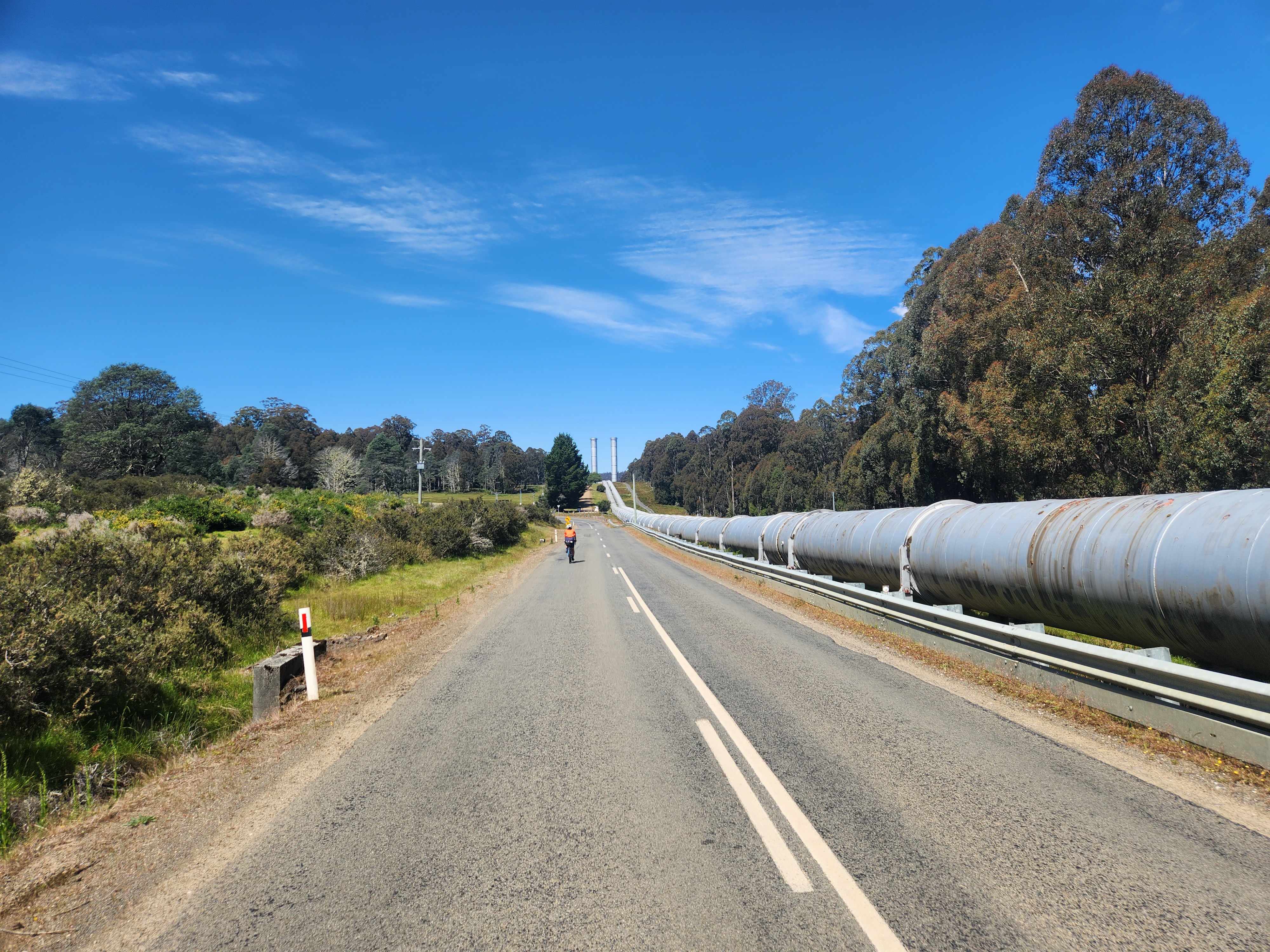 |
| Pipes feeding the Tarraleah Power Station |
Despite being on a mission, I took a short detour to admire the drop to the power station, before successfully scrounging some water from an administrator at the lodge. It was a far cry from what I'd been imagining, but it was what we needed most (we had plenty of food).
 |
| Tarraleah Power Station |
The water and rest were useful remedies, but probably the saving grace was Fourteen Mile Road - a lovely gravel back road that cut out a stretch of the Lyell Highway. There was less heat radiating off its surface, it was shorter, and for the most part shaded. We even saw our first live echidna - one of many, and just about the only non-bird animals we saw from our bikes that were not squashed!
 |
| Fourteen Mile Road |
The map had us hitting the highway again at Bronte Park, and after our experience with Tarraleah I wasn't holding my breath for a shop. Sure enough, low expectations were not surpassed, and we turned towards Lake St Clair for the final 25km run. The evening cool was helping Sarah immensely, and the scenery was helping me.

We'd splashed on a cabin at the Lake St Clair Lodge - the most expensive night of the trip - and the room was well up to scratch, even though we had no internet connection there (a plus in some eyes, I'm sure!). We'd been recommended to take a boat on the lake if we could, but the morning's 9am sailing only had space for an outbound journey. Sarah had no interest in a 3-hour hike back, which was a good call, and maybe not one I'd have been sensible enough to make myself. After a hard day in the saddle, we ate well, and enjoyed a short walk back to our cabin along the lake.

Stats: one long meltdown, two too few shops. 125km ridden, 2130m climbed, max temp 42 degrees.
Day 3 - Lake St Clair to Queenstown
A buffet breakfast was provided the next morning. Weird "coffee bags" were signalled as a perfectly good substitute for the cafe's coffee machine, which wouldn't be in use until 10am. We quietly disagreed, and wondered what the logic was...!
We'd walked to and from breakfast in overcast but dry conditions. The ride began with a 5km gentle climb back to the highway. It was plainly obvious that we'd slept through a very windy night, judging by the debris all over the road.
The road was passing through the Franklin-Gordon Wild Rivers National Park, and was suitably spectacular. We were passing through a massive plateau, at about 750 metres above sea level. It had been about 15 degrees when we set off, but the temperature dropped steadily through the first hour of riding and by the time it hit a low of 8 degrees or so, it was joined by light rain. Before we got near the start of the descent, I put my road-coloured jacket on, plus a fluoro vest over the top, and also my overtrou and buff. Sarah was much happier in the cooler air than I, and I knew better than to suggest she rug up. The overtrou were less about the rain, than about the wind chill, and having my quads and knees covered did wonders for my comfort levels.

When we did start to descend properly, we passed a couple of women doing the Tassie Gift bikepacking route. We stopped briefly to chat to them, during which time they were fumbling around in their bags for something to supplement their summer riding clothes. I'd had my storm gear on for at least 20 minutes, and was shocked that they'd ridden on for so long!


After running alongside Lake Burbury for a few kilometres, the road crossed it in spectacular fashion, and we couldn't see either extreme from the bridge.
 |
| Sarah crossing Lake Burbury |
We started to slowly climb away from the lake and reached a small settlement named Linda. There were conflicting signs as to whether we were about to score a coffee. A permanent sign on the remains of the Old Royal Hotel suggested the cafe was closed, but an "OPEN" flag was flying. After marvelling at the North Owen Descent visible on the ridge behind us, we went to investigate the coffee situation...
 |
| Black trail ahoy! |
Alas, while we could see the coffee machine was on through the window, there was no other sign of life. They had a covered but outdoor lounge which I chilled out in while Sarah made use of the bathroom, and then we headed back to the road, to tackle the final climb of the day.
 |
| So near, but yet so far |
At the top, we were faced with a couple of options that might have appealed on a warmer day, but definitely didn't in this cold wind - a 900m gravel climb for a viewpoint over the town, and a walking trail to see a waterfall. Instead, we enjoyed a nifty road descent, from which mellower MTB track was visible, and the town beyond it.
 |
| The climb at the end of "Waterfall" trail |
Entering Queenstown itself was a remarkable experience. There had been various clues we were in mining country, but the outskirts of Queenstown had clearly been built in the mine itself, and almost had the feel of sitting in a huge swimming pool. A small cutting led us out of that, and soon after we swung into the town proper. We made straight for our motel, checked in, washed, and made our way to the railway station cafe for a late lunch.

There I finally started to warm up, in part courtesy of a shared plate of loaded fries. While we were there, the train returned from its daily lap of the West Coast Wilderness Railway - booked solid months in advance, we were later told. The final carriage ferried white water rafts, and we were treated to a bit of manual turntable action before heading off to check out the town Museum.

There we chatted to Raymond, who gave us some rather sobering information about the transformation of Queenstown from a mining town into "a town with a mine" (currently closed due to unfortunate fatalities). The museum was full of fascinating artefacts, and we left with both a dinner recommendation and confidence to contact Aaron from the local bike shop despite it being closed for the holiday. Yet another perk of the short day's ride was an opportunity to give our riding kit a wash at the nearby laundromat.
By the time we knocked off for the evening, I had a 9am rendezvous set up with Aaron, and drifted off to sleep excited that the more annoying of my two problems was about to be solved.
Stats: one happy Mongolian, 93 kilometres ridden, only 900m climbed, average temp 11 degrees.
Day 4 - Queenstown to Zeehan
We woke early enough that we could head down to the railway station cafe again in civvies, and were checked out and fully suited up when we met Aaron and his son Zane outside West Coast Ride. Not long afterwards, I was sporting a new left-hand pedal, and the spare right-hand flat pedal in my frame bag had also been replaced. Even had the post office been open, I'm not sure my risk appetite would have let me post the surplus home at this point... We donated Ratho's flat pedals (which they seemed happy enough not to get back) to Aaron's parts bin.
We set off bound for Zeehan. The Lyell Highway would have got us there within a couple of hours, but we took a slightly longer route through Strahan. Slowly regenerating bush was masking some of the effects of decades of mining activity, but tell-tale signs were everywhere, including the stream passing through the town.


Once away from Queenstown we began getting views which were somewhat more appealing. We stopped at a layby to better admire the West Coast Range looming to the south of us. Sarah chatted to some locals while I went for a slash.

We peeled off about 300m of elevation largely in tree cover, so the "big reveal" of the ocean I was expecting never came. Sarah's near-death experience in the heat had also triggered a bit of pain and discolouration behind one of her knees, and she'd been somewhat successfully treating it with ibuprofen. We ducked into a chemist as we entered Strahan and ended up with some spray-on voltaren, which will live in the small first aid kit in my frame bag from now on. We credited the medication combo and my single-speeding for her recovery.
 |
| Strahan's other claim to fame...! |
Beyond Strahan was a bit of flat riding, during which I was hoping to pop out to the coast and was keeping an eye out for a dirt road that might get us there. The shortest distance between the road and the sea came and went, and soon after I spotted a huge sand dune in the trees. We went back to investigate, and after locking the bikes up, discovered a bit of a playground tucked away. After we'd groveled up the steep dune, we found several families boogie-boarding, and also discovered that the ocean was a loooong way away still - far too far to walk, even if we'd not had the bikes to worry about.

Eventually the road turned away from the coast and we began climbing. I was enjoying having both feet clipped in, but not so much the 12-degree slopes which were a struggle to ride. Looking back over the ocean was just about enough to make doing this loop in the opposite direction compelling - at some point rounding a bend to see this would have been awesome, and it was a shame we didn't experience the same in our direction of travel.


A couple of kilometres down the road we found the Zeehan Bush Camp. While I checked us in, Sarah sculled the whole bottle of chocolate milk, having missed the memo that it was to share! No scowling selfie after that, but all was soon forgiven as the mood was lifted by our awesome glamping setup. The whole thing seemed incredibly well thought through and delivered - pre-prepared firewood, marshmallows, private and shared facilities. All in all, a great experience, and I was very glad it hadn't fallen victim to a Boxing Day rejig.

After popping out for a dinner at the local pub, we came back to base, lit our fire, and were entertained by a Tasmanian nativehen, which is from the same family as the pūkeko, but in shades of green rather than the familiar deep blues. It was well worth a late night to see our tent (and our neighbours') all lit up.

Stats: two happy glampers, 90 kilometres ridden, 1100 metres climbed, max temp 26 degrees
Day 5 - Zeehan to Moina
We hadn't seen the town cafe when we'd gone out for dinner despite looking for it, so had bought breakfast supplies for the morning. Of course, that act had ensured we did stumble upon it on the way back to camp, but in any case, we rolled out well fed.
We had a pretty big day ahead, and various tasks to perform en route to our B&B about half way between Zeehan and Launceston.
Mining activity and paraphernalia was sometimes obvious, but other times not at all. Once back on the Lyell Highway, we passed a major facility on our left, which, to our great surprise, was excavating under the hill to our right. We stopped and watch a conveyor belt emanating from a tunnel that must have been only a couple of metres beneath us seconds before. I dare say an aerial tour of this west coast region would yield some pretty shocking sights.
 |
| Who would otherwise have known rock was being shifted under the road...?! |
Our host had warned us the only real shopping opportunity would come at Rosebery, sadly only a quarter of the way into the ride. There, we had a second breakfast, and then I set to trying to organise a new Di2 battery. I spoke to a very helpful person on the phone at the Launceston My Ride, only to discover at the very last moment that the battery they had was not the right one. Another store - Roll Cycles - was recommended, and with the help of a part number from Jesse Cseh (who had his feet up after a mind-boggling tour of the Whakarewarewa forest - literally all of it) and an incredibly pro-active salesman, Josh, I soon had purchased the necessary part, and had negotiated after hours delivery of it to our motel since we'd arrive after closing on new year's eve.
That sorted, we also bought a pack of pasta, tin of tomatoes and a couple of small tins of tuna for our dinner. Once that was lashed to the top of my saddle back, we set off again, an hour the poorer over a straight snack stop, but with some important tasks done.
As we climbed out of town, we were reminded of our mixed feelings towards the local drivers. On the one hand, they'd almost uniformly been incredibly courteous of us, giving us plenty of space on the road. On the other, we had passed an inordinate amount of roadship trash - including weird things like McDonalds or KFC wrappers, despite being hours away from either.
 |
| "STOP LITTERING PEOPLE" |
 |
| Chess on the shores of Lake Rosebery |
As if to reinforce the importance of the Di2 battery purchase, the afternoon's roads were incredibly tough. It was slightly mortifying to resort to tactical walks on a main road, but with gradients at or above 15% on a few occasions, I had no choice. An upside was it was easier to admire the scenery on foot, rather than chewing on my stem.

The road summit brought Cradle Mountain into view - a jewel in crown of "Tasmania's Outdoor Art Gallery".
 |
| Well played, Kentish! |
We did take a short side track, which gaves us amazing views over the dramatically (and aptly) named Vale of Belvoir. Cradle Mountain itself was off in the distance and not at all a dominant feature in this incredible landscape, despite the signage suggesting otherwise.
 |
| Vale of Belvoir, and Cradle Mountain mid-shot |
After grovelling up steep hills, the final hour or so of the ride wasn't so bad terrain-wise, but the weather deteriorated, and I ran out of physical and mental steam to an extent. Sarah was in her inclement element though, which was good. We passed both the turnoff to Cradle Mountain and a shit-load of rubbish in the the roadside ditches, and eventually arrived at our B&B, bedraggled and for my part, relieved. We'd been allocated the cabin named "Roland" and chuckled to discover its neighbour was called "Wellington".
The facilities were great, and the "breakfast basket" that had been supplied probably could have comfortably stretched to dinner as well, had we come unprepared. We made good use of the guest laundry, and also the spa bath!
Stats: one Di2 battery bought, 119km ridden, 2400m climbed (some on foot), max temp 37 degrees, final two hours steadily decreasing from 17 to 7.Day 6 - Moina to Launceston
When I plan a touring route, by and large I ignore the terrain and focus on distance and the bigger picture only. However it hadn't escaped my notice that we'd start day 6 by peeling off about 500 vertical metres, before painstakingly recovering most of it on the other side of the steep valley which we'd cross. With another day in hand, pushing north towards the coast would probably have avoided this natural feature, but we were headed eastwards towards "Lonnie".
A couple of minutes into our descent we took a side road which promised good views over Cethana Dam. There, I mustered up the courage to fire up our drone for the first time - a replacement for the one I'd put into a palm tree in French Polynesia (it wasn't the tree that killed it, but the foot of water it fell into...).
 |
| Cethana Dam on the Forth River, from above |

Once across the Forth River, I was pleased to note that my legs felt OK on the 300m climb that followed, despite the previous day's hammering. I was surprised to reach a saddle, at which was a cafe. There, I did a bit of route tweaking which cut out additional climbing, and we were pleased to descend gradually through Gowrie Park and Claude Road (one of the weirder place names I've seen).
 |
| Street art at Gowrie Park |
Claude Road (the road, rather than the place) took us around the looming Mt Roland Regional Reserve. Along its length, and a regular feature of West Coast properties that we'd passed were firewood stacks that reminded me of the immaculate ones I'd admired in Italy and France almost 10 years prior, and also gave a strong suggestion about the sort of winter conditions faced by Tasmanians.

Shortly after Claude Road (the place, rather than the road) we turned off to enact Plan C. We'd forgone the climb past Tasmazia which would have taken us into Sheffield, and also ignored the deviation to Mole Creek. Instead, we rode a mix of sealed and dirt roads through Paradise, Lower Beulah and Weegena and eventually to Deloraine, where we found a decent lunch stop.
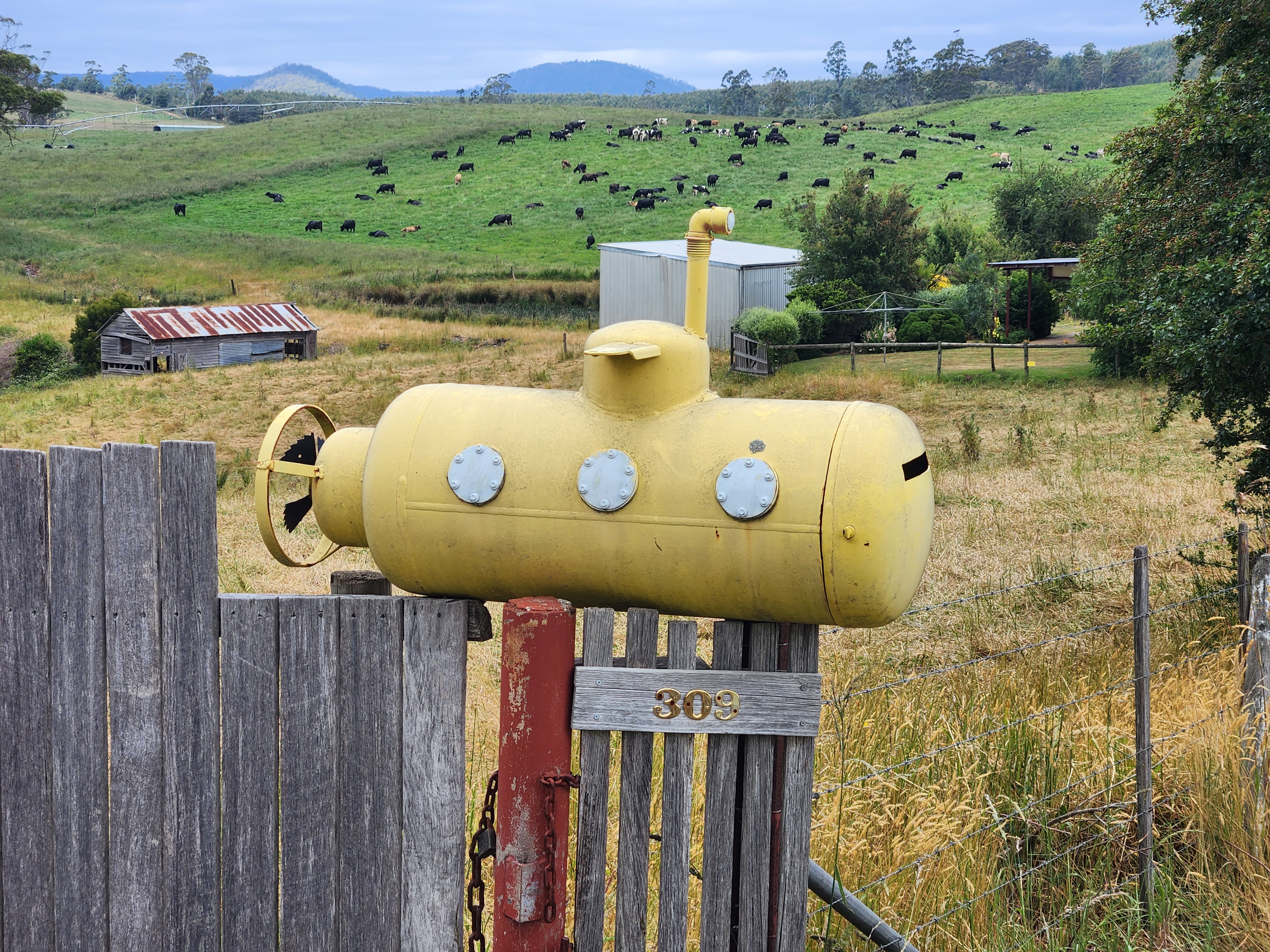 |
| Somewhere in Paradise, and high on my list of great letterboxes! |
From Deloraine, the road was pretty uninspiring, and seemed likely to have once been the main highway into Launceston - these days running parallel to the Bass Highway (A1 designated). I was having a great time (NOT!) spinning my legs like crazy on the slightly downhill terrain. I seemed to be able to maintain in excess of 25km/h, but frankly, the spin/coast/spin/coast pattern was wearing a bit thin, and on my undercarriage, almost literally. Bring on Lonnie.
We arrived at our motel just before 5pm, and at check-in, I was shocked to discover that nothing had been left for me, asking the clerk three times if he was sure nothing had been delivered. I hadn't had the wherewithal to ask for Josh's private number, and became a bit despondent at the thought of trying to clean the situation up once the store reopened on the 3rd of January. It all seemed like a bit of a disaster until about 15 minutes later there was a knock on our door, and there was Josh! At that moment, I realised that actually him dropping in late was worth the alarm it had caused, as I was able to give him a handsome tip for the after-hours hand delivery.
I was kind of expecting the battery to work out of the box, so blood pressure spiked again when it didn't. However, 10 minutes on the charger and everything came to life. I had a real spring in my step when we walked to the local shopping centre to grab kebabs for dinner, a fittingly simple meal to bring closure to a rough year...!
Stats: ending the day with TWO fully functioning bicycles (HALLE-FUCKING-LUJAH!!!!), 117km ridden, 1400m climbed, max temp 32 degrees.
Launceston Lay Day
We spent new year's day cruising around Lonnie in civvies, and generally having a low key day. I changed gears with gay abandon, which was a nice thing to be able to do. We were somewhat aimless, and simply followed our noses, to a great extent along dedicated cycle paths, which was great fun. A culinary highlight was a very delicious Cauliflower Cheese pie for breakfast from a Banjo's Bakery store.
 |
| A very impressive playground in Riverbend Park |
Stats: 53km ridden, no sunburn, despite not putting cream on and an average temp of 21 degrees.
Day 7 - Launceston to St Marys
Touring Day 7 also got an impromptu route adjustment. I'd planned to connect into the A4 south of the Ben Lomond National Park, but that was in anticipation of riding Jacob's Ladder in the north of the park on our day off. Alas, the torrid week prior had left us with little inclination to have a huge ride on our "day off", leaving the back roads that we would taken as prime candidates for our next day to St Marys in the hills above the east coast of the island.
Our motel's cafe was closed up for the festive season, so we made do with breakfast at a nearby Maccas. When we rolled out for good, the skies in the north were ominously dark, and we could hear the occasional rumble of thunder. For a while it looked like we might avoid getting hit, but eventually the skies briefly opened, and in the absence of convenient shelter we rode in the rain for a few minutes.
 |
| The North Esk River |
The road was sealed until soon after the Jacob's Ladder turnoff (which I was ever so slightly sad to skip, but under no illusions about our ability - or lack thereof - to squeeze it in). The dirt Roses Tier Road started gently enough, but it was clear from the ride profile (and the ridge we could see ahead) that we were in for a stern test soon enough.
 |
| No overtaking or passing on Tassie's one lane bridges, please |
When the steep part came - just over 2km with an average gradient of 14% - I rode the whole thing as a matter of principle. The fairly regular ramps exceeding 20% required careful traction management, but one advantage of being almost 100kg clothed and riding a loaded bike, was that the bike sticks to the ground like the proverbial. There was no way I'd have gotten up there a couple of days earlier, but with a full complement of gears, there was no way I wasn't going to ride it...!
The descent was much more gradual, and on the way we were (unsuccessfully) keeping an eye out for a ute that had lost a sack of fertiliser off their deck soon after passing us.
We took a punt and did a short side trip into Mathinna, only to find the store well and truly shut up. Instead we ate the snacks we'd hauled with us, before resuming our ride.

Soon after, and just under 20km short of meeting the main Esk Highway (A4), we turned off onto the C430 back road, almost immediately being treated to some apt road sign vandalism (a repeat of which we'd see once more a couple of days later).

The unsealed back route was lovely, and we were entertained by the birdlife - Forest Ravens and Black Cockatoos in particular (which we would both hear and see), but also the occasional Kookaburra laughing or Sulphur Crested Cockatoo screeching.
 |
| Marital bliss |

Stats: a few thunderstorms mostly dodged, 119km ridden, 1700m climbed, max temp 33 degrees.
Day 8 - St Marys to Little Swanport
On the way into town, and again during our walk, I'd seen advertising for the Mt Elephant Pancake Barn. Sadly, the internet was firmly of the belief that this was closed, which was more than a tad disappointing. The hotel provided cereal and toast though, and we chowed down on this, chatting to Carsten as we did so.
We left ahead of him, so were the first to discover that the route we were all intending to take - over Elephant Pass and then down to the coast - was closed. While this did save me from having to ride past the pancake place, the alternate route looked about to add 15km to our day's tally.
 |
| Closed |
There were a couple of silver linings, the first being that the northern route over St Marys Pass didn't kick off with a 150m climb like we would otherwise have been doing. Instead, after a very gentle rollout, we were descending most of the way to the coast.
Once down at sea level, we turned into a brisk headwind, and coats were on again, off again, until we reached the Elephant Pass intersection. Curiously, there the road shrunk, and for the rest of the day, we were riding without any shoulder, and with a rough edge to the pavement to boot. As it turned out, the road we weren't intending to ride was the nicest stretch of the day, at least looking straight downwards. For the most part, the drivers compensated for the road, which was greatly appreciated.

We stopped for a bite to eat in Bicheno, a small town which seemed to be absolutely pumping. It was lunchtime, but I assumed that because it wasn't great beach weather, things were busier than normal. Today's pie variety was curried scallop, and it was pretty damn fantastic. Scallops did seem to be less of a luxury here than back in NZ, and when in Rome...
It had been really hard to find accommodation along this East Coast route, and the best I could come up with was a bush camp a wee way from the nearest shops. Rather than haul dinner ingredients and take our chances with the facilities, we decided to stop in Swansea, and have a dinner-like afternoon tea (which turned out to be a so-so meal of fish and chips). We left with some goodies in our rarely-used backpack, namely a loaf of bread, some spreads (the supermarket conveniently sold single serve packs of peanut butter and jams for 25 cents each - horrible for the environment, but very cost effective and efficient), some soup sachets, and a packet of biscuits. That'd do us for supper and get us on the road in the morning. Sarah reported good legs, and volunteered to do the hauling, which I gladly accepted. I was bound to get things sweaty, and I appreciated the effort she was putting in.
I was slightly nervous about navigation, but shouldn't have been as the camp was well signposted off the main road.

At check-in we rented a couple of sets of linen, and were also able to buy a couple of small chocolate milks and a can of mushroom soup for Sarah (which had been requested but unavailable at the IGA in Swansea). Once washed up, we had a few sandwiches each with our soup, washed down with some bikkies.

Stats: one 15km detour, 139km ridden, 1300m climbed, max temp 20 degrees.
Day 9 - Little Swanport to Eaglehawk Neck
After demolishing the rest of our loaf of bread and a couple of instant coffees each, we rolled out. I'd caught a fleeting glimpse of a kangaroo on the ride up to the camp the previous evening - literally the first we'd seen off the bike - but we were able to enjoy one more clearly soon after leaving the premises.

Back on the highway, it was just over 20km to Triabunna, where we found a cafe for a second breakfast. Before settling on a place, we waved to a couple of elderly cycle tourists who'd stopped for the night in Swansea, and had clearly made a much earlier start than us. When we chatted the day before, the woman told us she was soon to be in the South Island and had some great bikepacking lined up.
Orford was less than 10km further down the road, and there we turned off. Almost immediately was a sign for the "Wielangta Road Forest Drive" which sounded very appealing. I checked my planned route and discovered that we would hook into this road in about 12km. After a bit of humming and hahing, I decided to stick with the plan, and continue along the coast for a bit.

The great views we soon got out towards Maria Island and along the coastline reinforced that decision. The road itself was also interesting, with a couple of weird cattle-stop/gate combos, and soon after a switch to a gravel surface.

Even better, the road was virtually deserted, oh, and I had two clip in pedals and 22 gears, a privilege I was still conscious of.

The traffic volume increased ever so slightly when we joined Wielangta Road, and it seemed many were ignoring the 4WD suggestion, ourselves included. I didn't see anything that would have troubled a regular car, but perhaps it is a different story in the wet or extreme cold.

The road got hilly, but the surroundings were fantastic, and well worth the effort. At one point we had a fast descent onto a bridge, and I did feel a tad fortunate to survive the pot-hole minefield that lay immediately beyond. Fortunately, while I temporarily lost control of my eyeballs, I maintained command of my bicycle, as did Sarah her own.

Wielangta terminated at Bream Creek Road, and offered a multitude of options through to Dunalley. We turned left, and were treated to various fascinations en route.
 |
| The first "store-like" thing we'd passed in a couple of hours |
 |
| e-scooter commuters |
 |
| Scallop harvesting? |
We were headed for the Tasman Peninsula, which has the curious feature of two very narrow points between it and the mainland. One is at Dunalley, where there's "the only purpose built sea canal in Australia", the Denison Canal, about 900m long.
 |
| Denison Canal |
After a wee break at the local bakery, we started our final push towards our destination, Eaglehawk Neck (the other pinchpoint, to the tune of about 100m wide at high tide). It was hottish, and the scenery fairly uninspiring, but I did get a tad scratchy at Sarah when she described the ride as boring! We saw more creative sign vandalism, and ... I'm speechless now as I was then...
 |
| Tasmanian Devil |
We had a lovely descent which had to be sharply curtailed so we didn't overshoot the driveway of our accommodation. Then began our familiar routine of unpacking, setting up the charging station, washing bodies, washing clothes, and eating.
While waiting for our dinner to settle, I was fascinated by a display in the lobby which showed how well and truly part of the Australian continent Tasmania is.

Once ready, we headed across the road, to discover what on earth "Tessellated Pavement" was. I vaguely knew the mathematical term, tessellation, but still find it fascinating that the exposed rock shelf was described as pavement. It was also kind of weird to be free to walk all over it, but I guess there's little that walkers will do to it that wave action will not.
 |
| Tessellated Pavement, Eaglehawk Neck, TAS |
Stats: one beautiful forest road, one bored and subsequently scolded Mongolian, 107km ridden, 1555m climbed, max temp 23 degrees.
Day 10 - Eaglehawk Neck to Port Arthur
We had a short ride ahead when we set off from Eaglehawk Neck after breakfast. The direct route to Port Arthur would have been about 20km, but there were a couple of deviations I planned to take, keeping the shorter route for the return journey. We set off in lovely conditions, but about 10 minutes later, the jackets came out and went on.
 |
| Looking back at Eaglehawk Neck |
Pirates Road was signposted with "No Through Road", Australia's equivalent to NZ's "No Exit". We ignored that, but soon after, staring up a bit of a wall, at an adjacent "Road Closed Ahead" sign, and with rain starting to fall, we decided to pull the pin on deviation number one.
Back on the main drag, we soon reached Taranna, and turned off in the direction of Nubeena. At Koonya, we turned onto Nubeena Back Road, and unsealed gem, which looked like it might cut a little distance of the remaining ride, but surely at the expense of some climbing.
Fortunately, the gradients were fairly mellow, and the surface lovely, and we were soon descending into Nubeena. There we stopped at a cafe for a couple of coffees, and I warmed up a bit. I was expecting a small town at Port Arthur, so was surprised to discover a strange setup, where a decent chunk of the "road network" on my map was actually part of the Port Arthur Historic Site, and fenced off. After coming upon one fence across the road, we then stumbled upon our Motel. Despite it being relatively early, we were given our key, a place to get changed, and were offered a secure space to leave our bikes in. Our room key worked in a nearby gate that took us into the historical site, which was kind of weird, as it then became a bit of a battle to get our pre-booked tickets figuratively clipped.
We spent a good few hours wandering around, and had a short boat trip around the harbour. I was glad not to have done any homework on the place, as it was chilling to read about the more recent grim history of the place, on top of having walked around the rather depressing "Separate Prison", named not for its location relative to the penitentiary ruins, but for the isolation of the prisoners from one another. Even the chapel had individual standing boxes. Oh the horrors mankind inflict on one another, and continue to do so...

Stats: roughly 40km of riding, followed by a 10km walk and boat ride combo
Day 11 - Port Arthur to Hobart
The Tasmanian Devil Unzoo back at Taranna was just the antidote for the Port Arthur site, and we were treated to some rather animated and close quarter devil viewing. I'd read some unduly harsh Tripadvisor reviews of the place the night before, but we really enjoyed our short visit.
 |
| Surprisingly, these cute wee fellas have only a 7-year lifespan, if not cut short by the Devil Facial Tumor Disease |
As well as the devils, we walked amongst some kangaroos chilling out, and enjoyed seeing some nice forest on an old TV set, sort of!
 |
| BUSH TV |
The climb out of Eaglehawk Neck was short but sharp, but the road back to Dunalley was surprisingly painless, particularly given the criticism it had elicited in the other direction. We revisited the bakery we'd stopped at the day before, and then ducked and dived our way back to Hobart.
 |
| Connelly's Marsh and the Tasman Peninsula in the rearview mirror |
I thought we might stumble on a nice beach to stop at - the temperature seemed to invite going for a dip somewhere - but it wasn't to be, which was odd. Perhaps we didn't look hard enough at the right times (Carlton Beach looks like it might have escaped our notice), but in any case, we didn't stop.
After a loo break in Sorell, cycle paths took us most of the way to the airport, where I popped in to explore the availability of bike boxes. A Qantas rep implied it would be pretty trivial to buy boxes from them when we flew a couple of days later, but warned us they'd be $40 apiece.

With that intel locked in, we continued on towards Hobart, albeit via a bit of tiki-touring which eventually elicited a bit of grizzling from my companion. By that stage we were fully committed though, and a fairly direct route hence took us to our motel for two nights near the Botanical Gardens, which took a bit of circumnavigating.
We walked to a nearby Indian restaurant, where we were very lucky to be fed, due to impending bookings. That's where our good fortune ended, kind of, and we went to bed without a dessert course.
Stats: four cute Tasmanian Devils seen, 118km ridden (about 20km more than the direct route), 1450m climbed. Max temp 30 degrees.
Hobart tourist day
We almost didn't do any riding on our final full day in Hobart, instead enjoying being driven around a few of the sights by our recent Broulee and Canberra hostess, Joanna.
Pretty much everyone we mentioned our upcoming Tasmania trip to had urged us to go to MONA, and it lived up to the hype. (Digging out the link just now alerted me to a slight bit of good fortune that we didn't coincide with their days off on Tuesday and Wednesday!) My highlights were mostly of the New Art variety (including a computer controlled fountain that "wrote" words, and a machine that recreated the human disgestion system - we saw it being fed, but not the end product...). The museum in which the art was housed was a work of art in and of itself, too.

After a visit to Jo's incredible 93-year-old Aunt Margie, where we also had the pleasure of meeting some of Jo's cousins, we finally managed to reconnect with Carsten, having missed him on the Tasman Peninsula.
Over a perfectly sized seafood platter, we made commitments to get in touch with one another when we were next in New Zealand and Europe respectively.
 |
| Great dinner and dinner companion! |
Airport drama
After all the joy that using one's own bike in a distant place brings, last minute logistical headaches are such a drag. We turned up at the airport about 100 minutes before the bag drop closed, almost half of which were spent discovering relieving Qantas of their boxes was nowhere near as simple as we'd been led to believe it would be a couple of days prior.
 |
| The end of the easy part |
An Air New Zealand rep hadn't batted an eyelid when I approached her desk asking if they had boxes for sale. 10 minutes later I was standing next to a couple of Qantas boxes, and 10 minutes after that, I was being told that Qantas couldn't sell them to me as I wasn't their customer, and Air New Zealand couldn't sell them to me as they weren't theirs to sell. To the Air NZ staff member's credit, after giving me the "it is your responsibility to have your bikes properly packed, and we will not accept them if they are not" statement, she continued to try to negotiate a solution. Nothing seemed to be happening, and after helping a Qantas passenger lift her suitcase onto the scales, I kicked myself for letting her go without asking her to buy the boxes on my behalf. I accosted the next Qantas passengers, who seemed willing to take $80 cash from me to do just that, but no sooner had I secured that "out", the Air NZ rep seemed to get permission to sell me the boxes herself. After what seemed like an eternity feeding her credit card and other details, I declined to receive a receipt via email, and moments later was trotting down the terminal with a couple of boxes under my arm, feeling relieved that I still had time to pack them!
In any case, all's well that ends well, and we were soon admiring our hard-won handiwork as we made our way onto the plane.

Stats: one bike packing drama to wrap up one great bike-packing trip, 1273km ridden, a few bullets well dodged.
* * *
Despite the stressful bookends, I really enjoyed my first visit to Tasmania, a spot that is begging for a rerun, perhaps with a mountain bike and campervan.
We saw way less wildlife than we expected - even the amount of road kill seemed less that what we'd seen between Sydney and Canberra, and that came as a real surprise.
Aside from the day when Sarah suffered in the heat (and nearly died, she's convinced), I was glad to bear the brunt of the bad luck on this trip. Thinking about it, had Sarah's battery and pedal both shat themselves, we might have quickly ended up in the same position, but anyway, it was nice to be able to overcome the pedal and battery issues. If anything, it was better that I was slightly hamstrung, as it enabled Sarah to ease into things slightly more gradually and overcome her knee tendonitis without it getting too bad.
For planning purposes, and while riding, I found a plastic Tasmania State & Cities map a great pre-purchase. Andrew Bain's book had some useful tips, but isn't really a tour-planning tool. The Tasmania chapter in Lonely Planet's Cycling Australia book has suggestions not unlike what we ended up doing, though not identical, in the opposite direction, and with typically shorter days.
The Open U.P. (Unbeaten Path) rigs and Revelate bags are a fantastic package for this sort of thing, and one of these days we will have a niggle free trip. Were it not for the pedal and battery issues, I'd have been claiming we returned with a near perfect setup (especially with the nail clippers and anti-inflammatory spray safely stowed). We used a lot of the gear we carried, and the stuff we didn't touch (spare tubes, tyre boots and plugs, spare mini pump, arm warmers, gloves, Sarah's overtrou) are not things that could be left at home.
I didn't use the drone nearly enough, and upon seeing the quality of the two photos I did take, makes me realise I should be taking many more. As a camera with infinitely adjustable tripod goes, the DJI Mini 3 Pro and DJI RC controller fit easily within a Revelate Egress waterproof pocket (itself adding about 300grams, but additional useable space), and with a bit of additional packaging, weigh a mere 733 grams. MUST. USE. IT. MORE.
 |
| Packed weight: 733g. Mementoes: priceless |
I keep writing how nice it is that my body copes with these trips without doing much riding in between, but I need to stop using that as an excuse for not doing much riding in between. I'm 49 years old, and should know better by now...!
2023 has some nice riding prospects ahead: at Easter we will be flying into Bangkok, and have enough time to do about a week's touring, either in Thailand alone, or perhaps from Cambodia back to Bangkok. In June, we have flights booked as far as Seoul, with a three week window during which time we'll visit Sarah's (and my) sister, niece and grand-nephew in Mongolia, and do some riding in both places. Closer to home, there are roads around Palmerston North and Dannevirke that I've not yet ridden, and many more further afield. Plus, the local roads that I've ridden countless times, but enjoy each time I actually do...
Wishing all my regulars a wonderful new year, and greetings to those that randomly stumble upon this post and miraculously get this far!
 |
| John and Sarah's Tasmanian Devil Tour: 1273km, between 25 Dec 2022 and 8 Jan 2023 |