With the exception of the very first cycle tour I ever did - from Wanaka to Hokitika in my early 20s - I've favoured the "credit card" tour approach, namely travelling without camping gear. The benefits as I seem them are compelling, but not all equally obvious.
- Cycling is nicer when you're not hauling too much luggage, and once you commit to camping, your gear list tends to explode (or your comfort levels suffer, or both). Not only shelter, but a sleeping bag, mat, and probably cooking gear as well. The list goes on...
- Not only is the riding nicer without luggage, but it is hard to beat sleeping in a real bed.
- Hygiene matters, and staying somewhere with shower, soap and a towel or two means a good wash for the body, and a decent wash for your riding shorts, if not other clothing.
- Cell phone and navigation device are both critical, and having an overnight power source is ideal. Lights and if you're unlucky, Di2 battery might also need charging.
- Finally, a hotel room or storage facility make for a relatively stress-free dinner outing, whereas camping you might want to find a spot well out of sight so that your rig is guaranteed to be where you left it when you went to bed.
Despite all those good reasons to do it, and despite having zero regret at the many amazing credit card tours I've done, there's nonetheless part of me that doesn't feel like a "real" cycle tourist.
Well and truly back on the travel horse, Sarah and I accepted an invitation to visit the Canberra branch of our family - my father Geoff and his wife Joanna - in a 10 day period that would include Labour Weekend. The format? Credit card touring of course.
Day 1 (Thursday) - Sydney International Airport to Wollongong
The holiday began in arduous fashion, with a 6:30am flight out of Wellington to Sydney. We considered a couple of options to ease things slightly, but in the end decided to sleep in Karori and put up with the drive across town in the wee hours.
Geoff and Jo had offered to meet us in Sydney, and they were waiting for us once we'd cleared customs. We found a spot to unpack the bikes and chatted away until we were ready to roll. Our bike bags went to Canberra in the back of G&J's car, but not before they'd caught up with some friends in the big smoke.
Originally their advice had been to catch the train away from the airport, but Strava's heat map showed there was plenty of cycling activity to or from the airport, and so it seemed worth at least trying to ride. Indeed, there was walking/cycling signage as we exited the terminal, and after heading up one level in the parking garage, we found ourselves very well catered for indeed. Wollongong, here we come!
 |
| 10/10, Sydney International Airport |
I'd mapped out a route to Cronulla and knew that we needed to get there by 11:30 to avoid a detour around Port Hacking. I'd used Strava's route builder for the first time, and had benefitted greatly from the overlay of the map and the heatmap, to the extent that there was little need to deviate when the "on the ground" options seemed better than what I'd selected during the mapping exercise.
Remarkably, almost the entire 20km ride to Cronulla was on off-road paths. Some were dedicated paths along waterways and well away from traffic (and for that matter, everything), while others were adjacent to roads. In any case, it was a surprise, and quite a treat. Initial impressions were that Australia is miles ahead of NZ in dedicated cycling infrastructure.
Aside from the cycle ways, there were a few other keen reminders that we were somewhere new - not least the birdlife, including several flocks of sulphur-crested cockatoos, grazing or a-wing.
We didn't stop much, and made the Bundeena ferry with only a couple of minutes to spare, but without stress. Had we missed the 11:30 boat, the next wasn't until 1:30, and that would have been too much time to kill over lunch. Before leaving home, I'd found a couple of $20 bills which I thought might have been useful to pay for tickets, but the conductor seemed to assume we'd pay by payWave, and I went with the flow - a sign of things to come.
 |
| Sarah boarding the 11:30am Cronulla to Bundeena ferry |
The ferry ride was lovely. It added a nice dimension to the morning's riding, but was also a nice sight-seeing activity and an opportunity to chill out for half an hour or so. At Bundeena, we had a couple of tasks which were both dealt to not a minute's ride from the wharf - lunch, and then a quick supermarket visit for some riding snacks.
One of the lovely things about planning a route is that is still leaves plenty of surprises, one of which was a hefty climb out of Bundeena. It felt very Australian, with plenty of gum trees although no conspicuous wild-life. The road was quiet and the occasional cars gave us plenty of space.
 |
| Royal National Park |
At the top of Bundeena Drive, we came to a major intersection and turned south. I'd recalled a gravel option from my planning phase, but had failed to associate that choice with missing the ferry (Lady Carrington Drive, along the Hacking River). On the other hand, it was nice not to be confronted with a difficult choice - at the last minute we'd packed our Opens, so were much more gravel-ready than we'd originally intended. On the other hand, it had been raining recently, and we were enjoying being clean and care-free.
The riding was nice, and occasionally we spotted interesting wildlife, including a black cockatoo, some sort of insect nest up in a tree, and a deer - the latter I'd originally thought (and hoped) was a kangaroo, but while the "face" was rather similar, the rest of it was not. Along the tops the bush was pretty scrappy, but for much of the ride we were amongst mature trees which felt much more worth of being in a national park.
Eventually we passed a small settlement, and soon after reached a lookout giving us great views down the coast, and in particular to Sea Cliff Bridge. We stopped for a few minutes to admire the sights and then got underway again.
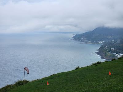 |
| Glider landing zone in the foreground, and Sea Cliff Bridge in the distance |
Had I done my homework properly, I'd have known the next major intersection took us onto the main route of the World Road Championships that were recently hosted by Wollongong. Unlike most of the pro-tour, the viewing hours had been very friendly, and I had enjoyed watching a few of the races on TV. While we weren't going to deliberately go out of our way to experience the course, the ride through to the outskirts of Wollongong was that little bit more enjoyable because of the recent event.
 |
| Sarah (illegally) on Sea Cliff Bridge |
I vaguely recalled from the race commentary some mention of cyclists being unable to ride on the "footpath" at the rather magnificent bit of engineering that is the Sea Cliff Bridge. I imagine on a warm summer's weekend, the ban would make a lot of sense, but mid-week, the path was pretty much deserted, and even had we noticed the signage at the start, we'd have likely ignored it. On our way off the bridge, I did pay it more attention, and noted that we didn't meet any of the criteria (under 12, adult supervising someone under 12, under 18 being supervised by an adult responsible for a child rider). A nicer sign might have said "don't be a dick" and made do. Up until that point, we'd felt not only incredibly welcome, but also very well catered for!
The rest of the ride into Wollongong was enjoyable, and much of it on dedicated paths again. Our accommodation was near Flagstaff Point, and before checking in we made the most of our wheels to do a little bit of sightseeing.
The walk back never seems as long as the walk there, and this was true to form. We even got to enjoy watching a pelican grooming itself off in the distance, and got back to our room without getting rained on.
Stats: 90km, mostly ridden
Day 2 (Friday) - Wollongong to Vincentia
 |
| "Bike Friendly Business" |
As fun as it might have been to check out a few of the worlds' climbs, we had a decent day's cycling ahead of us, and accommodation booked in Vincentia. We followed our noses around the heavy industrial area surrounding Port Kembla. While the scenery wasn't great, all indications were that we were on the right path.
 |
| Pelicans at Coomaditchy Lagoon |
I had a few navigational issues at Shell Cove, but picked up some neat cycle ways through some very wet wetlands - we'd clearly missed a recent downpour. Not long afterwards, we came alongside the M1 Princes Highway. There was a great cycle path alternative but we soon discovered that much of it was underwater! It literally looked like we had no alternative but to proceed through the shin deep water, trying not to think too much about what was contributing to the colour!
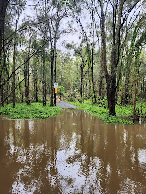 |
| Dry land at the "Cyclist dismount" sign seemed to invite the opposite |
The flooding was a bit of a drag, but aside from wet feet and a bit of a delay, it was soon a squelchy memory.
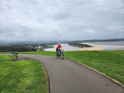 |
| Minnamurra lookout |
The rest of the ride through to Kiama was a neat mix of quiet roads and paths through reserves. At Kiama, we stopped for coffee and a muffin, and then went to see the local blow-hole (marketed heavily from kilometres away along the Kiama Coast Walk). Sadly it was not at full noise given relatively light sea conditions.
The voyage of discovery took a confusing turn when we were drawn on to Princes Highway for the climb out of Kiama Heights. At this point it downgrades from M1 (a motorway, no bikes allowed) to A1, and it was somewhat reassuring to soon after see a bike-warning sign - surely redundant on a road that bikes shouldn't be on!
At Gerringong we were able to leave the main road for a while. I admired Sarah from about 50m back, while also wishing I was only 5m back so I could tell her I wanted to stop for a slash.
 |
| Industry on the outskirts of Nowra |
Neither of us felt the need for a stop in Nowra, which we passed through on paths alongside Princes Highway. The southern end of town seemed like an endless stream of "big box retailers" - a sight which is probably increasingly familiar to Aucklanders, but is still pretty novel through this Wellingtonian's eyes.
The highway had a fairly good shoulder, but after a day and a half's riding on mostly dedicated cycling infrastructure, it was a bit of a downer. We got shouted at by at least one passing passenger - "get off the fucking road" or similar. Fittingly, we passed a "beware cyclists" sign minutes afterwards, resolving any concern I had that I'd missed a turn off.
It was a pleasure to leave the main road about 20km from our destination, and have an hour's relatively peaceful riding to Vincentia. To cap the day off nicely, there was even a great gravel path for the final kilometres. Our legs felt well worn by the time we'd made our way up the hill to our Airbnb, not helped by a bit of navigational confusion.
After a wash, we trotted down the hill for dinner at a local Thai restaurant and a supermarket visit for the morning's breakfast supplies. We enjoyed a zombie movie on Netflix before sleeping solidly, as you tend to do after days like this...!
Stats: 125km ridden
Day 3 (Saturday) - Vincentia to Broulee
The destination for our third day was Geoff and Jo's home-away-from-home at Broulee Beach, just south of Bateman's Bay.
After about 15km of riding the the 'burbs, we rejoined Princes Highway, which we were stuck on for much of the day.
While birds had been in abundance throughout the trip so far, we hadn't seen much other wildlife save a handful of kangaroos behind a fence. There were clearly wombats around, because once an hour or so, we'd pass one which hadn't quite made it across the highway. One was impressively maggot-laden, and I made the foolish decision to linger to point it out to Sarah (she'd reported missing all others I'd seen to this point, but I really should have picked a nicer one to bring to her attention)!
 |
| Oh-Mah-Got!!! |
Heritage Bakery in Milton was well advertised, though from agonisingly far away for a cycle-tourist, who doesn't quite bash out the kilometres like a car can. The road got incredibly narrow on the last minutes into town, made worse by the fact that wombat remains had to be negotiated (somehow the spine was about 10 metres away from the rest of it, and both collections were in the way).
I was surprised to "arrive" in Milton, such as it was perched on the top of the hill - I can't think of any places in NZ that are built on hilltops. We eventually found the bakery at the far end of town - they proudly announce themselves to be "Australia's First Cashless Bakery". Up until that point, we'd literally not spent any cash (the opposite of quick, clean and accurate, apparently), but this really hammered home that at various times, we might not have had the choice.
Societal curiosities aside, the bakery served up some pretty tasty baked goods, and we rolled out again well sated. We took backroads that largely bypassed Ulladulla, but we were soon back on Princes Highway. I was preoccupied by one of my Achilles tendons, which felt a little funky - not sore, but it was stinging intermittently, like I'd scratched it and was getting sweat in it. I popped some nurofen and tried not to think about it.
After Ulladulla, an enticing bit of gravel singletrack running parallel with the road along a power line, gave us some further respite from the traffic, but it didn't last long, especially after skipping the first section or two.
A service station at the turnoff to Bawley Point gave us an opportunity to have a cold drink and for me to look at some route options. The Old Princes Highway was very tempting, but despite its parallel bearing with the new highway, looked like it would add too much distance. I was still concerned about my tendon, though there was no obvious change in its status.
Up ahead we could see some very dark clouds, which had prompted a very kind local woman to stop her car and offer us shelter! We politely refused for all manner of reasons - a small car with two sweaty cyclists in and the windows up would quickly become unpleasant for all involved, and besides, we were there for the outdoor adventure.
The woman was prescient, though it took the best part of 10 minutes more riding before the heavens really opened. Most of the lightning strikes were a way off, but one happened unnervingly close given the volume of the thunder (incredibly loud) and the lack of delay between the thunderclap and the lightning flash!
We ordered a couple of hot chocolates while trying to keep the dripping on the floor to a minimum. The cafe doubled as a museum (or vice versa) and there some old motorcycles and even a bicycle or two to admire while we enjoyed our drinks.
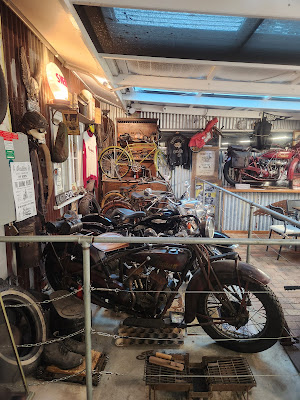 |
| Fuel East Lynne museum pieces |
The rain hadn't fully abated when we headed off, but we were confident we wouldn't get any wetter than we already were! A little under an hour later, we were back onto cycle paths and crossing the very grand and relatively new bridge over the Clyde River into Bateman's Bay.
With Geoff and Jo's place not far away, we didn't stop, and instead cycled on under the (lousy) assumption that the last 20km would be a cruise. I navigated on the fly, at every opportunity comparing what we could see on the ground against the plotted route. That approach took us on a deviation through Denham's Beach, before bringing us to a major roundabout on George Bass Drive. All we could see ahead were hills, so we opted for the one that looked less savage. That didn't last, and around the first major bend, we found ourselves staring up a wall!
After what can only be described as a grovel, we picked up the rather lovely Dunn's Creek Road on which we peeled off all our hard-won elevation. This route (favoured by google) felt odd, but was partially explained the next day when we saw renovations of the Princes Highway from the vantage point of G&J's car, which had closed an off-ramp. After a bit of ducking and diving, we made the turnoff to Mossy Point, and soon after were being greeted by our hosts.
Day 4 (Sunday) - Broulee
The following day, we enjoyed being shown around the neighbourhood. This included a walk along the beach, scanning for whales from a headland, and seeing an actual live wombat at an animal park in Bateman's Bay. Sarah and Jo hired Stand-Up paddle boards while Geoff, the dog Sydney and I went for another walk.
Before dinner, we dusted off four bikes and went for a spin a wee bit further south.
Having paid money to see Australian wildlife earlier in the day, it was slightly ironic to see a wild kangaroo in amongst the trees for the first time. I attempted to point it out to Sarah, but only Geoff understood my gesticulations.
Stats: 20km, sedately ridden
Day 5 (Monday) - Broulee to Braidwood
Tendon diagnostics at various times on our lay day had suggested the slight discomfort on the ride to Broulee might remain a mystery, which suited me very well indeed. As a result, we were a well oiled family machine once we surfaced, with a clear plan of attack formulated the previous night.
G&J had to be back in Canberra by late morning, but were comfortable that they'd have enough time to drop our overnight gear at our accommodation in Braidwood - about half way between their two homes. That meant Sarah would be riding a bare bike for the day, while I had my handlebar bag with rain gear, plus tools and tubes etc.
Unfortunately, my preferred route, following the Deua River on Araluen Road, was out of action, having been closed by slips in early 2020. Had the weather been primo, I'd have put a bit of effort into identifying the feasibility of getting through by bike (despite the formal closure notification), but it had rained again overnight, and what with reports of heavy rain that we'd been seeing in the media over the last week, it seemed like a really dumb idea to try. Similarly, I ruled out another couple of shorter detours, and decided to keep things simple (and clean).
 |
| Bridge over the River Clyde |
Despite having had breakfast relatively recently, we shared a big plate of pancakes in Bateman's Bay, washed down by coffee.
As with the earlier days, conditions were warm enough to be riding in short-sleeved jerseys, but the odds of rain seemed high! There also seemed a fair chance that we wouldn't enjoy the main road much, but it was a Monday morning, and we hoped there wouldn't be too much extra traffic to trouble us on our climb up the Illawarra Escarpment - or "Scarp", as the locals sometimes refer to it.
While the King's Highway didn't cater directly for bikes, it was a perfectly pleasant road to be on - usually there was a decent shoulder, and besides, Australian drivers seemed much more bike-aware and bike-tolerant than their neighbours over the ditch.
 |
| A sign eliciting thoughts of Oli (alive and well!) and my dear old cat, Misty (RIP) |
Slowly but surely we chipped away at the ascent, from the coast to a highpoint of almost 800 metres above sea level. The road was under construction in a couple of places, and the stop-go system ensured we had intermittent car-free patches once we were past them. There were some seriously epic switchbacks where at least one of us was happy not to have any onlookers!
 |
| Sarah cresting the summit |
After dealing to the climb, we had a 20km run into Braidwood - where we hoped to avail ourselves of a visit to Dojo Bread, highly recommended by G&J. Beating the 2pm closing time went down to the wire, and as with the Cronulla Ferry, we arrived with a few minutes to spare. The $10 pies were worth every cent, mine beef, and Sarah's lamb. Both delicious, and warming, all the better for being from the inside out.
 |
| Dojo Bread, Braidwood |
Another advantage of arriving early enough to go to Dojo, was that we had the afternoon to chill out. First, we checked into our hotel, stashing our bikes in an alleyway under the back of the hotel - I was assured "there's no crime in Braidwood", a comment which we got a few giggles from when it became apparent that some baked goods that G&J had left with our luggage had vanished.
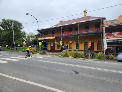 |
| Royal Mail Hotel, Braidwood |
Once washed and in civvies, we headed out on foot, and explored the various stores on the main road (i.e. the town). It isn't something we often do, usually arriving closer to dinner time than lunch time, and eventually we settled down in an eclectic cafe-cum-bookstore-cum-eclectic-emporium. There we supped our hot drinks, and played on the internet a bit before mooching back to our room to put our feet up.
We ate dinner in the hotel restaurant, and then had a somewhat unsettled start to the night with rowdiness coming first from the pub, and then from our balcony! A couple of interventions eventually quietened things down, and we got some solid sleep.
Stats: 87km ridden, including one whopping hill
Day 6 (Tuesday) - Braidwood to Canberra
Before suiting up, we chose another cafe for a good cooked breakfast. As I was paying, I asked the staff about the road through Captains Flat, which Jo had recommended we take. They both thought the "dirt road" - which started about 30km from Braidwood - would be really muddy, so I committed to continuing along King's Highway, at least as far as Bungendore.
 |
| Ukraine on the minds of the people of Braidwood |
From time to time I dust off the old chestnut "Better to regret something you did, than something you didn't", and I reminded myself of this at pretty much every dirt road we passed - all looked in absolutely primo condition, and I lamented asking a barista and a shop assistant for advice, rather than popping into the gas station which might have been the source of more pertinent intel. Nothing for it but to enjoy the countryside though.
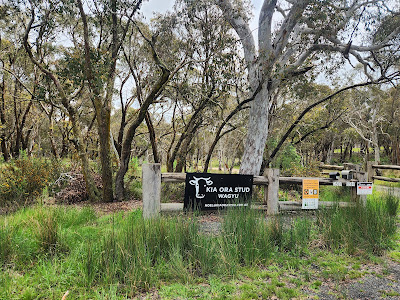 |
| Occasional reminders of home, if you kept your eyes peeled |
About half way to Bungendore the road turned due west, and so began a 20km stretch with a nasty headwind. At Bungendore we had a bite to eat, before picking up a back road that would cut out much of the highway riding through to Queanbeyan. It was nice to ride a quieter road, and with a direction change thrown in to mitigate the wind.
Towards the end of this leg I was relieved that a ford was passable - had it not been, we would have been looking at almost an hour's riding back to where we had lunch...!
 |
| Crossing the Molonglo River on Briars Sharrow Road |
It wasn't too long before we started catching glimpses of Canberra off in the distance, including the Telstra Tower on Black Mountain, but also, more surprisingly, the fountain in Lake Burley Griffin!
 |
| Declined |
Once back on the cycleway we rode most of the way to G&J's home in Narrahbundah on paths, shared with some curious customers, including a boy with a petrol-powered bicycle.
 |
| BRAAAAAAPPPP! He pulled a manual moments later |
We were warmly welcomed once again, bringing a close to the cycle-tour element of the trip. My original plan had been to spend a couple of nights in Canberra before touring back to Sydney, however, Plan B had been enacted, which consisted of a train booking. It meant less pressure on our hosts and ourselves, but also an opportunity to explore Canberra a bit more.
Stats: 95km ridden
Canberra ride (Thursday): Lake Burley Griffin
The following day, we did a lap of Lake Burley Griffin together, virtually 100% on cycle ways. The ride had a bit of everything, and despite being a school day, there were plenty of other users on the lake-side path to keep us on our toes.
 |
| Mongolian and New Zealand flags flying in close proximity |
I'd done the ride once before, from memory in the opposite (anti-clockwise) direction. My young sister Millie and I had visited in the mid-90s, and had done the ride together on a rented tandem. I dredged out memories of regular jolting as she tried to get her feet back on the pedals after losing her place! From memory I insisted she hang her legs away from the pedals, so at least the extra work was undisturbed!
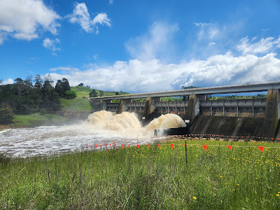 |
| Scrivener Dam |
After crossing the Scrivener Dam at the bottom of the man-made lake, we soon were exploring the Australia National University campus, where Geoff had taken time out to complete a PhD late in his diplomatic career.
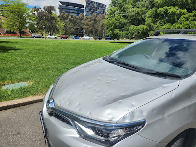
Someone's parked car showed signs of both a figurative and literal hammering, presumably courtesy of a weather event rather than a disgruntled neighbour.
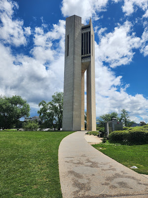 |
| National Carillon, Lake Burley Griffin, Canberra |
Between the Carillon and home we enjoyed a bit of retired roadway, and hid from another rain-shower in a conveniently located hide adjacent to wetlands. Just before leaving the lakefront for good, we were shown a curious sign which welcomed its readers in three languages, one of them te reo Māori.
 |
| Photo: Joanna Adamson |
Stats: 40km ridden
On Wednesday, we'd driven out to Tidbinbilla Nature Reserve - a route which was crying out for a repeat visit on our bicycles. Friday was my birthday, and it seemed fitting to spend the day riding with my dear wife, and despite it feeling slightly unadventurous, I was keen to re-tread familiar ground.
When we set out, the sun was shining, but fortunately it was cool enough that I grabbed my sleeveless vest. While that proved a god-send, at various times during the day I regretted leaving in haste, and without well enough flipping the mental switch between cycle touring and recreation. (Live and learn, and write about it to better let the lesson sink in.)
We were relatively well oriented, given the drive, but I was nonetheless mindful that knowing the way by car doesn't always translate into cycling directions, and particularly in a place not only rich with cycle paths, but also where the roads swoop this way and than in an endless sequence of curves.
 |
| Cycle path alongside Cotter Road |
Sure enough, paths took us to the outskirts of Canberra and past the Stromlo Forest Park, laden with MTB trails (and on the list of future attractions to visit). From there, the route transformed into a rural road with little traffic on it.
 |
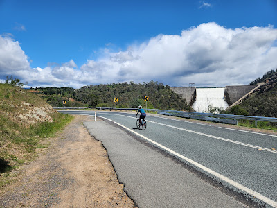
| Water supply from Cotter Dam towards Canberra |
Despite seeing the Cotter Dam from the car, I was nonetheless excited about it coming into view. The rectangular wall of white cascading water takes a bit of deciphering when you first see it in the distance.
After a quick re-hash of our drive into the base of the dam, we proceeded onwards towards Tidbinbilla. By this stage, Sarah had announced her Di2 battery was near flat - initially signalled by the front derailleur ceasing to work. I'd honestly thought we'd identified the problem, and had flown with the battery disconnected on both bikes. But, despite that precaution, it seems like the single-bike discharge mystery continues. To make matters more annoying, I kicked myself that the power bank and cable was stowed in our baggage already, and not in my frame bag.
That wasn't the only bit of kit I was regretting being without. The air was decidedly cold, and I knew I'd be much happier with arm warmers on at the very least, but more likely my Shakedry jacket. While trying to minimise gear shifts in solidarity with Sarah, preoccupation with gear shifting was soon overcome by weather concerns - I began wondering how bad the wind-driven rain was going to get, and hoping that it would miraculously clear.
Fortunately, the rain seemed to be hold off, so that only my windward side was wet (and very cold, not to mention very pink). Fortunately signage at the turnoff to the Canberra Deep Space Communication Complex signalled that the cafe was closed - it would have been a gamble, and a huge bummer to have gone there to find nowhere to hide from the rain (and we might have got wet in both directions, front and back). When we arrived at the nature reserve turnoff a few minutes later, the weather ahead looked to be perking up, so we agreed to keep moving, and to make hay while the proverbial sun shone.
We ignored the Point Hut Rd turnoff, and continued on to Tharwa, where we crossed the Murrumbidgee River and swung around towards Canberra. We re-enacted lunch at the Lanyon Homestead, before getting out into the cool air again.
We eventually made it back to Geoff and Jo's, with a relatively enjoyable, if not trouble-free ride under our belts. It would have been a 5-star ride had we had the power bank and our jackets, but even without, it was a bloody good day on the bike.
Stats: 109km ridden
(Saturday) Closing the loop
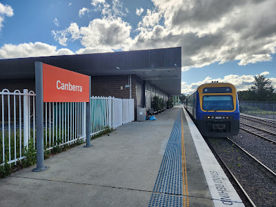
Our final day in Canberra involved only a very short late-afternoon ride, to the railway station for our evening train to Sydney.
There we packed our bike bags, and confronted the slight possibility that our bags would be rejected. When I'd finally looked at the fine print in our train tickets the evening before, I discovered that I'd made dubious assumptions about how easy it would be to get our bikes on. The NSW Trainlink website referred only to boxes, and while I'd spoken on the phone with someone the previous day who'd read a statement about "commercially produced bicycle bags" also being OK, she couldn't guarantee it.
To our great fortune and relief, there was no issue. Both my Scicon bag and Sarah's Torpedo7 knockoff easily clocked in under the hard limit of 20kg, and the clerk didn't bat an eyelid about their dimensions. Once more, the train journey seemed like a great solution for our return to Sydney.
A few hours later, after a very pleasant and effortless journey, we were transferring onto the Airport train service at Sydney Central Station, and after an easy 10 minute walk from the Mascot stop, we were checked into a hotel for the night.
The next morning, we had a trip milestone when paying for the shuttle to the airport. The $10 a-head fee was the first and last transaction of the trip made in cash...! The COVID-19 pandemic truly seems to have accelerated Australia's transformation into a cash-free economy. I'm still too scared to look at my visa statement, in fear of finding a hefty per-transaction fee...!
* * *
This 10-day break in Australia was a lovely antidote to a stressful preceding period at work. The format was novel, and I don't recall ever mixing riding and non-riding activities to this extent. Geoff and Jo were not only wonderful hosts, but had also helpfully done some hard yards in terms of logistics, all of which we greatly appreciated. I'm certain we'll return to Canberra - I'd like to spend some time there exploring, and will be keeping my ear out for an announcement that the Araluen Road has been reopened. Perhaps the next trip will involve flying into Canberra, and looping through Broulee to the south.
We got lucky with the weather. It was warm enough, but never hot. And we saw evidence of heavy downpours nearby, both in the media, and through occasional first-hand evidence, all the while without really being hit from above (with one notable exception)!
Travelling with bikes remains a pain-in-the-arse, which is such a shame, as once in a place, there's little that beats bike riding. Our next trip is to Tasmania, over Christmas and New Year. I've already committed to boxing the bikes, so that we can ditch them at the airport and ride away. The advantage is not having to store our bags, offset by the multiple disadvantages of refitting the handlebar and seatpost, heightened risk of damage, and sourcing boxes at the far end of the trip. Swings and bloody roundabouts!!
In all we rode about 700km while in Australia, which is almost double the proper riding I've logged since covering a similar distance in Fiji in June. It is disappointing to have really gone off the boil in response to work pressures, and physical issues (especially lower back) which I seem determined not to address. I think to some extent I've become addicted to bike holidays and "burbing", and any other sort of riding, particularly in the face of my other excuses, seems to hold little appeal. I don't expect that declaring it will make much of a difference, but oh well. The upside is my body seems to have done enough riding to be able to knock out 100km days when needed, irrespective of the long dry spells. Fortunately Sarah seems to cope well too, despite significantly fewer years in her legs.
Strava's Route Builder was a great trip-enhancer, and was used throughout to great effect. The phone app interface was awesome, particularly with the ability to see popular routes. I also appreciated whatever magic I'd enabled in the back ground which pumped my saved routes almost immediately to my Garmin. What a dream...
 |
| Nice work, Strava |
Lastly, a tip of the hat to the Australian central and local governments, for their investment in extensive, high-quality cycling infrastructure. It is a bloody big country, and I guess that brought with it less original pressure on space. While perhaps retro-fitting paths hasn't been as difficult as it will be (hopefully) in New Zealand, they've nonetheless got on and done it. Chapeau, and thanks.








Another cracking adventure! Thanks for the great read, as always.
ReplyDeleteGood to be able to do so much on dedicated bike/walk paths.
ReplyDeleteWe hope to be in Whanganui soon...will think of you as we go to the café in Uponkongaro on our bike rides
Another cracking adventure! Thanks for the great read, as always.
ReplyDelete